IMAGES TAKEN NEAR TO
Church Road, LEEDS, LS26 8BQ
Introduction
This page details the photographs taken nearby to Church Road, LS26 8BQ by members of the Geograph project.
The Geograph project started in 2005 with the aim of publishing, organising and preserving representative images for every square kilometre of Great Britain, Ireland and the Isle of Man.

There are currently over 7.5m images from over14,400 individuals and you can help contribute to the project by visiting https://www.geograph.org.uk
Image Map
Images are licensed for reuse under creativecommons.org/licenses/by-sa/2.0
Notes
- Clicking on the map will re-center to the selected point.
- The higher the marker number, the further away the image location is from the centre of the postcode.
Image Listing (53 Images Found)
Images are licensed for reuse under creativecommons.org/licenses/by-sa/2.0
Image
Details
Distance
1
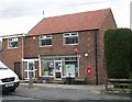
Post Office - St Aidan's Road, Great Preston
Image: © Betty Longbottom
Taken: 27 Mar 2008
0.01 miles

4
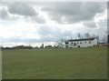
Cricket Pitch - Berry Lane, Great Preston
Image: © Betty Longbottom
Taken: 27 Mar 2008
0.06 miles
5
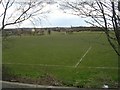
Football Pitch - Berry Lane, Great Preston
Image: © Betty Longbottom
Taken: 27 Mar 2008
0.08 miles
6
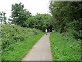
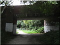
Cyclists heading south on the Lines Way
The Lines Way is a permissive bridleway on the route of the former Garforth - Allerton Bywater railway line.
Image: © Christine Johnstone
Taken: 26 Aug 2012
0.09 miles
8

The New Inn - Berry Lane, Great Preston
Image: © Betty Longbottom
Taken: 27 Mar 2008
0.10 miles