IMAGES TAKEN NEAR TO
Manor Crescent, LEEDS, LS26 0QS
Introduction
This page details the photographs taken nearby to Manor Crescent, LS26 0QS by members of the Geograph project.
The Geograph project started in 2005 with the aim of publishing, organising and preserving representative images for every square kilometre of Great Britain, Ireland and the Isle of Man.

There are currently over 7.5m images from over14,400 individuals and you can help contribute to the project by visiting https://www.geograph.org.uk
Image Map (Loading...)


Getting Data...Please wait
Leaflet Map data © OpenStreetMap
Images are licensed for reuse under creativecommons.org/licenses/by-sa/2.0
Notes
- Clicking on the map will re-center to the selected point.
- The higher the marker number, the further away the image location is from the centre of the postcode.
Image Listing (65 Images Found)
Images are licensed for reuse under creativecommons.org/licenses/by-sa/2.0
Image
Details
Distance
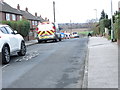
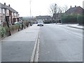
1
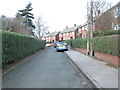
Castle Road - looking towards Manor Crescent
Image: © Betty Longbottom
Taken: 25 Feb 2014
0.03 miles
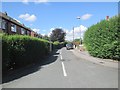
2
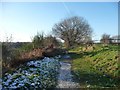
Gated path, south of Manor Crescent, Rothwell
A former colliery railway line.
Image: © Christine Johnstone
Taken: 30 Dec 2014
0.06 miles
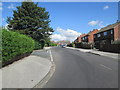
5
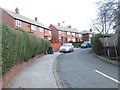
Albany Road - looking towards Manor Crescent
Image: © Betty Longbottom
Taken: 25 Feb 2014
0.07 miles
8
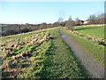
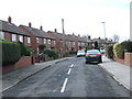
Path running west from Rothwell
Once an industrial area along Haigh Beck, now public open space.
Image: © Christine Johnstone
Taken: 30 Dec 2014
0.09 miles
10
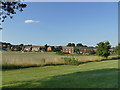
Manor Crescent recreation ground
Viewed from the nearby rail trail Image
Image: © Stephen Craven
Taken: 23 Jul 2019
0.11 miles