IMAGES TAKEN NEAR TO
Station Road Industrial Estate, Station Road, LEEDS, LS25 7QH
Introduction
This page details the photographs taken nearby to Station Road Industrial Estate, Station Road, LS25 7QH by members of the Geograph project.
The Geograph project started in 2005 with the aim of publishing, organising and preserving representative images for every square kilometre of Great Britain, Ireland and the Isle of Man.

There are currently over 7.5m images from over14,400 individuals and you can help contribute to the project by visiting https://www.geograph.org.uk
Image Map
Images are licensed for reuse under creativecommons.org/licenses/by-sa/2.0
Notes
- Clicking on the map will re-center to the selected point.
- The higher the marker number, the further away the image location is from the centre of the postcode.
Image Listing (52 Images Found)
Images are licensed for reuse under creativecommons.org/licenses/by-sa/2.0
Image
Details
Distance
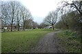
1
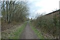
Alongside Station Road Motors
The Lines Way is a cycle path from Garforth to Allerton Bywater along the former railway line. It is designated as part of National Cycle Network route 697. The building on the right was presumably a goods shed for Kippax railway station.
Image: © DS Pugh
Taken: 18 Mar 2023
0.02 miles
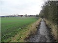
2
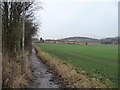
The path to Great Preston
A short cut between the village along Station Road, and the secondary school on Brigshaw Lane.
Image: © Christine Johnstone
Taken: 5 Jan 2013
0.03 miles
3
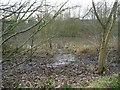
Pond and carr, south of Great Preston
East of The Lines, a former railway line.
Image: © Christine Johnstone
Taken: 5 Jan 2013
0.06 miles
4
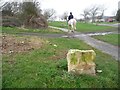
Boundary stone, Great & Little Preston parish
Alongside The Lines near the former site of Kippax station.
Image: © Christine Johnstone
Taken: 5 Jan 2013
0.06 miles
5
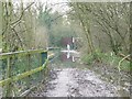
Where walkers fear to tread, Great Preston
Horse and rider using the flooded Lines [a permitted bridleway and former railway], north of Brigshaw Lane.
Image: © Christine Johnstone
Taken: 5 Jan 2013
0.07 miles
6
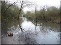
Flooding on The Lines, north of Brigshaw Lane
Pretty well impassable without wellingtons or a horse.
Image: © Christine Johnstone
Taken: 5 Jan 2013
0.08 miles
7
The path to Brigshaw High School
A short cut for the students who live in Great Preston.
Image: © Christine Johnstone
Taken: 5 Jan 2013
0.09 miles
8
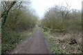
Path near Brigshaw Lane
The Lines Way is a cycle path from Garforth to Allerton Bywater along the former railway line. It is designated as part of National Cycle Network route 697.
Image: © DS Pugh
Taken: 18 Mar 2023
0.09 miles
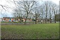
9
Site of Kippax Railway Station
The Lines Way is a cycle path from Garforth to Allerton Bywater along the former railway line. It is designated as part of National Cycle Network route 697.
Image: © DS Pugh
Taken: 18 Mar 2023
0.10 miles
10
Former Kippax Railway Station
Looking across to Berry Lane from The Lines Way at the site of the former station.
Image: © DS Pugh
Taken: 18 Mar 2023
0.11 miles