IMAGES TAKEN NEAR TO
The Sycamores, LEEDS, LS25 5FE
Introduction
This page details the photographs taken nearby to The Sycamores, LS25 5FE by members of the Geograph project.
The Geograph project started in 2005 with the aim of publishing, organising and preserving representative images for every square kilometre of Great Britain, Ireland and the Isle of Man.

There are currently over 7.5m images from over14,400 individuals and you can help contribute to the project by visiting https://www.geograph.org.uk
Image Map
Images are licensed for reuse under creativecommons.org/licenses/by-sa/2.0
Notes
- Clicking on the map will re-center to the selected point.
- The higher the marker number, the further away the image location is from the centre of the postcode.
Image Listing (18 Images Found)
Images are licensed for reuse under creativecommons.org/licenses/by-sa/2.0
Image
Details
Distance
1
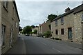
Cottages in South Milford
Houses on High street.
Image: © DS Pugh
Taken: 13 Jun 2021
0.04 miles
2
The Queen o' t' owd Thatch
Public house on High Street in South Milford.
Image: © DS Pugh
Taken: 22 Aug 2021
0.04 miles
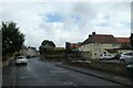
3

Forresters Arms
Forresters Arms, South Milford just past the church.
Image: © Darren Haddock
Taken: 6 Sep 2006
0.05 miles
4
Old milestone
This stone is now preerved on Northfield Lane off High Street in South Milford. It was found lying in the soil at the southern end of South Milford when the South Milford and Sherburn by-pass was built. It was rescued and set up at the entrance to a farmhouse. The left face has the legend LON/181/FER/4 and on the adjacent side facing the lane YORK/17/TAD/8. It is marked on Jeffrey's 1771 map.
Image: © Chris Minto
Taken: 9 Jan 2022
0.08 miles
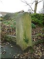
5

Old Milestone by Well Lane, South Milford Parish
Carved stone post was on the A162 originally, possibly close to GR: SE 4949 3072, in parish of SOUTH MILFORD (SELBY District), roadside, now by Well Lane off High Street, South Milford, at entrance to Northfield Farm, on North side of lane. Tadcaster plate, erected by the Doncaster & Tadcaster turnpike trust in the 18th century.
Inscription reads:- : LON / 181 / FER / 4 : : YORK / 17 / TAD / 8 :
Milestone Society National ID: YN_DNTC19a.
Image: © C Minto
Taken: 15 Oct 2006
0.08 miles
6

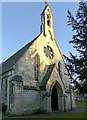
Church of St Mary, South Milford
Built 1846 by George Fowler Jones in Gothic Revival style. Listed Grade II. General view from the north east.
Image: © Alan Murray-Rust
Taken: 9 Dec 2019
0.09 miles
7
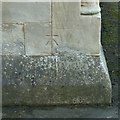
Bench mark, Church of St Mary, South Milford
See http://www.geograph.org.uk/photo/6345469 for location.
Image: © Alan Murray-Rust
Taken: 9 Dec 2019
0.10 miles
8
Church of St Mary, South Milford
Built 1846 by George Fowler Jones in Gothic Revival style. Listed Grade II. West front. There is a benchmark http://www.geograph.org.uk/photo/6345465 on the far corner.
Image: © Alan Murray-Rust
Taken: 9 Dec 2019
0.10 miles
9

South Milford war memorial
In the form of an ornate Celtic cross on a wide plinth. Adjacent to the north side of the church.
Image: © Alan Murray-Rust
Taken: 9 Dec 2019
0.10 miles
10
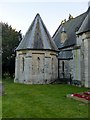
Church of St Mary, South Milford
Built 1846 by George Fowler Jones in Gothic Revival style. Listed Grade II.
The unusual octagonal vestry on the north side of the church.
Image: © Alan Murray-Rust
Taken: 9 Dec 2019
0.10 miles