IMAGES TAKEN NEAR TO
Grange Farm Court, LEEDS, LS25 4EB
Introduction
This page details the photographs taken nearby to Grange Farm Court, LS25 4EB by members of the Geograph project.
The Geograph project started in 2005 with the aim of publishing, organising and preserving representative images for every square kilometre of Great Britain, Ireland and the Isle of Man.

There are currently over 7.5m images from over14,400 individuals and you can help contribute to the project by visiting https://www.geograph.org.uk
Image Map (Loading...)


Getting Data...Please wait
Leaflet Map data © OpenStreetMap
Images are licensed for reuse under creativecommons.org/licenses/by-sa/2.0
Notes
- Clicking on the map will re-center to the selected point.
- The higher the marker number, the further away the image location is from the centre of the postcode.
Image Listing (69 Images Found)
Images are licensed for reuse under creativecommons.org/licenses/by-sa/2.0
Image
Details
Distance
1
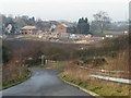
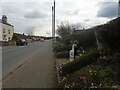
New housing development, Grange Farm, Micklefield
Seen from the western end of the A1[M] overbridge, across the route of the former Micklefield by-pass.
Image: © Christine Johnstone
Taken: 11 Dec 2013
0.01 miles
2
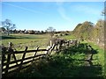
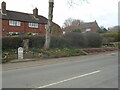
Footpath east of Micklefield
Just west of, and parallel to, the former route of the A1.
Image: © Christine Johnstone
Taken: 10 Nov 2013
0.05 miles
3
2000+ Years Anglo Scottish Trade Route
Spelt out in flowers on the Great North Road at Micklefield.
Image: © Ian S
Taken: 23 Apr 2016
0.06 miles
4
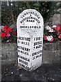
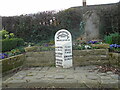
Old Milestone by the Great North Road, Micklefield
Metal plate attached to stone post by the UC road (old A1), in parish of MICKLEFIELD (LEEDS District), Great North Road, Old Micklefield; North of Churchville Drive, in flowery recess, on West side of road. WR iron casting, erected by the County Council in the 19th century.
Inscription reads:-
: ABERFORD / 2½ MILES / WETHERBY / 9¾ MILES / BOROUGH / BRIDGE / 22 MILES : : FERRYBRIDGE / & / BOROUGHBRIDGE / ROAD / MICKLEFIELD : : FERRY / BRIDGE / 7 MILES / DONCASTER / 22 MILES :
Milestone Society National ID: YW_FBBB07.
Image: © C Minto
Taken: 27 Jul 2005
0.06 miles
5

2000+ Years Anglo Scottish Trade Route
Spelt out in flowers on the Great North Road at Micklefield.
Image: © Ian S
Taken: 23 Apr 2016
0.06 miles
6
Old milestone
Facing southwards, three small areas can just be seen on the slope behind the two posts. This is where 2000+, ANGLO, and SCOTTISH have been planted.
Image: © Chris Minto
Taken: 5 Mar 2023
0.07 miles
7
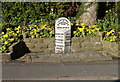
Old milestone
Either side of the milestone and its surrounding small garden are planted areas spelling out, at the southern side, 2000+ ANGLO SCOTTISH. And to the north, seen here, TRADE ROUTE.
Image: © Chris Minto
Taken: 5 Mar 2023
0.07 miles
8
Old milestone
Winter pansies in the little garden surrounding this West Riding County Council milestone on the old Great North Road. 615 of these milestones were erected all over the old West Riding in 1893/94. 9 of the posts on the 29 miles between Ferrybridge and Boroughbridge can still be found on now minor roads once the main road.
Image: © Chris Minto
Taken: 5 Mar 2023
0.07 miles
9
Mileage Marker
On the Great North Road at Micklefield.
Image: © Ian S
Taken: 23 Apr 2016
0.07 miles
10
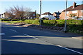
Telephone box on The Great North Road, Micklefield
Image: © Ian S
Taken: 23 Apr 2016
0.08 miles