IMAGES TAKEN NEAR TO
Hall Farm Park, LEEDS, LS25 4DP
Introduction
This page details the photographs taken nearby to Hall Farm Park, LS25 4DP by members of the Geograph project.
The Geograph project started in 2005 with the aim of publishing, organising and preserving representative images for every square kilometre of Great Britain, Ireland and the Isle of Man.

There are currently over 7.5m images from over14,400 individuals and you can help contribute to the project by visiting https://www.geograph.org.uk
Image Map (Loading...)


Getting Data...Please wait
Leaflet Map data © OpenStreetMap
Images are licensed for reuse under creativecommons.org/licenses/by-sa/2.0
Notes
- Clicking on the map will re-center to the selected point.
- The higher the marker number, the further away the image location is from the centre of the postcode.
Image Listing (34 Images Found)
Images are licensed for reuse under creativecommons.org/licenses/by-sa/2.0
Image
Details
Distance

2
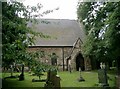
St Mary the Virgin, Micklefield
The parish church of Micklefield.
Image: © John Davidson
Taken: 29 Aug 2005
0.10 miles
3
Grassy area in the churchyard
This churchyard is managed as a wildlife space, in partnership with the Yorkshire Wildlife Trust, and is full of wild flowers. There is hawkbit in this grass.
Image: © Christine Johnstone
Taken: 12 Jun 2010
0.11 miles
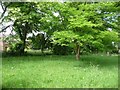
6
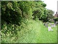
Churchyard hedgerow
This churchyard is managed as a wildlife space, in partnership with the Yorkshire Wildlife Trust, and is full of wild flowers.
Image: © Christine Johnstone
Taken: 12 Jun 2010
0.11 miles
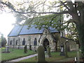
7
![Churchyard of St Mary the Virgin, Micklefield [1]](https://s3.geograph.org.uk/geophotos/01/91/00/1910031_3304ef0e_120x120.jpg)
Churchyard of St Mary the Virgin, Micklefield [1]
This is managed as a wildlife space, in partnership with the Yorkshire Wildlife Trust, and is full of wild flowers.
Image: © Christine Johnstone
Taken: 12 Jun 2010
0.11 miles
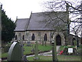
8
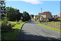
Entering Micklefield from the North
The Great North Road entering Micklefield - the former A1, now relegated to a quietish lane from Aberford.
The current A1(M) now by passes the village to the east.
Image: © Chris Heaton
Taken: 11 Jul 2020
0.11 miles
9
![Churchyard of St Mary the Virgin, Micklefield [2]](https://s2.geograph.org.uk/geophotos/01/91/00/1910046_0b3a8a34_120x120.jpg)
Churchyard of St Mary the Virgin, Micklefield [2]
This is managed as a wildlife space, in partnership with the Yorkshire Wildlife Trust, and is full of wild flowers.
Image: © Christine Johnstone
Taken: 12 Jun 2010
0.12 miles
10
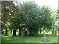
Churchyard tree
The churchyard is managed as a wildlife space, in partnership with the Yorkshire Wildlife Trust, and is full of wild flowers.
Image: © Christine Johnstone
Taken: 12 Jun 2010
0.12 miles