IMAGES TAKEN NEAR TO
Bodiham Hill, LEEDS, LS25 2LF
Introduction
This page details the photographs taken nearby to Bodiham Hill, LS25 2LF by members of the Geograph project.
The Geograph project started in 2005 with the aim of publishing, organising and preserving representative images for every square kilometre of Great Britain, Ireland and the Isle of Man.

There are currently over 7.5m images from over14,400 individuals and you can help contribute to the project by visiting https://www.geograph.org.uk
Image Map (Loading...)


Getting Data...Please wait
Leaflet Map data © OpenStreetMap
Images are licensed for reuse under creativecommons.org/licenses/by-sa/2.0
Notes
- Clicking on the map will re-center to the selected point.
- The higher the marker number, the further away the image location is from the centre of the postcode.
Image Listing (68 Images Found)
Images are licensed for reuse under creativecommons.org/licenses/by-sa/2.0
Image
Details
Distance
7
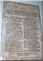
World War 1 Memorial at St. Mary's, Garforth
This plaque made of marble contains the names of the men from Garforth who left the village to fight in World War 1 and never returned.
Image: © John Readman
Taken: 9 May 2006
0.07 miles
8
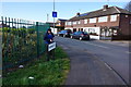
Bagging a Munzee on Firthfields, Garforth
Munzee is a game where you scan a little barcode sticker with your mobile phone.
Image: © Ian S
Taken: 23 Apr 2016
0.07 miles
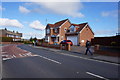
10
Sturton Lane - viewed from Dunrobin Avenue
Image: © Betty Longbottom
Taken: 30 Aug 2016
0.08 miles