IMAGES TAKEN NEAR TO
Lotherton Way, LEEDS, LS25 2GD
Introduction
This page details the photographs taken nearby to Lotherton Way, LS25 2GD by members of the Geograph project.
The Geograph project started in 2005 with the aim of publishing, organising and preserving representative images for every square kilometre of Great Britain, Ireland and the Isle of Man.

There are currently over 7.5m images from over14,400 individuals and you can help contribute to the project by visiting https://www.geograph.org.uk
Image Map (Loading...)


Getting Data...Please wait
Leaflet Map data © OpenStreetMap
Images are licensed for reuse under creativecommons.org/licenses/by-sa/2.0
Notes
- Clicking on the map will re-center to the selected point.
- The higher the marker number, the further away the image location is from the centre of the postcode.
Image Listing (94 Images Found)
Images are licensed for reuse under creativecommons.org/licenses/by-sa/2.0
Image
Details
Distance
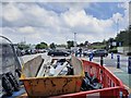
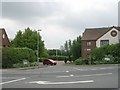
1
Lotherton Way - viewed from Parkinson Approach
Image: © Betty Longbottom
Taken: 19 Jul 2016
0.03 miles
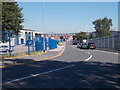
2
Parkinson Approach - off Aberford Road
Image: © Betty Longbottom
Taken: 19 Jul 2016
0.06 miles
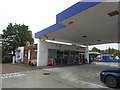
5
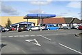
Toll Bar Garage Ltd - Aberford Road
Image: © Betty Longbottom
Taken: 19 Mar 2008
0.08 miles

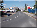
7
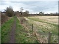
Public footpath along the edge of Garforth
North of, and parallel to, Lotherton Way.
Image: © Christine Johnstone
Taken: 27 Mar 2015
0.10 miles
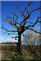
9
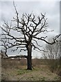
Dead tree alongside Garforth's perimeter footpath
Grass growing along the lowest branch and burnt-out at the bottom of the trunk.
Image: © Christine Johnstone
Taken: 27 Mar 2015
0.11 miles