IMAGES TAKEN NEAR TO
Long Lane, LEEDS, LS25 2DS
Introduction
This page details the photographs taken nearby to Long Lane, LS25 2DS by members of the Geograph project.
The Geograph project started in 2005 with the aim of publishing, organising and preserving representative images for every square kilometre of Great Britain, Ireland and the Isle of Man.

There are currently over 7.5m images from over14,400 individuals and you can help contribute to the project by visiting https://www.geograph.org.uk
Image Map (Loading...)


Getting Data...Please wait
Leaflet Map data © OpenStreetMap
Images are licensed for reuse under creativecommons.org/licenses/by-sa/2.0
Notes
- Clicking on the map will re-center to the selected point.
- The higher the marker number, the further away the image location is from the centre of the postcode.
Image Listing (27 Images Found)
Images are licensed for reuse under creativecommons.org/licenses/by-sa/2.0
Image
Details
Distance
1
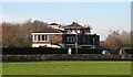
Garforth Golf Club
The course was closed during the Covid-19 restrictions. See also Image
Image: © Stephen Craven
Taken: 8 May 2020
0.01 miles
2
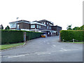
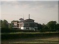
Garforth Golf Club House
It may be December and there are men on the roof, but it seems unlikely that either are Santa Claus.
Image: © Gordon Hatton
Taken: 14 Dec 2018
0.01 miles
4
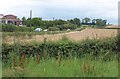
Long Lane
A view of the road between Garforth and Barwick in Elmet from Parlington Lane across a field of wheat. On the left is Image
Image: © Derek Harper
Taken: 1 Aug 2011
0.04 miles
5
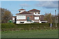
Garforth Golf Club
On Long Lane between Barwick and Garforth.
Image: © John Davidson
Taken: 2 Sep 2005
0.05 miles
6
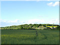
Farmland alongside Parlington Lane
The hint of yellow suggests a rape crop starting to flower. Throstle Nest Farm is visible in the background.
Image: © Stephen Craven
Taken: 8 May 2020
0.07 miles
7
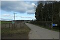
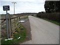
Parlington Lane from Barwick Road
A bridleway runs along Parlington Road between Barwick Road and Aberford. This path forms part of National Cycle Network route 66, with this section connecting Leeds and York.
Image: © DS Pugh
Taken: 11 Feb 2023
0.09 miles
8
![Crossing Garforth golf club by public footpath [2]](https://s1.geograph.org.uk/geophotos/02/57/78/2577849_d82af110_120x120.jpg)
Crossing Garforth golf club by public footpath [2]
The footpaths around Barwick and Scholes are clearly way-marked, although this particular one is not heavily used.
Image: © Christine Johnstone
Taken: 29 Aug 2011
0.09 miles
9
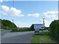
Sign for Willow Park farm shop
The sign is at the junction of Long Lane and Ellis Lane. For the shop, see Image
Image: © Stephen Craven
Taken: 8 May 2020
0.10 miles
10
Private road, public bridleway
Parlington Lane, immediately east of Barwick Road.
Image: © Christine Johnstone
Taken: 27 Mar 2015
0.10 miles