IMAGES TAKEN NEAR TO
Town End, LEEDS, LS25 1QD
Introduction
This page details the photographs taken nearby to Town End, LS25 1QD by members of the Geograph project.
The Geograph project started in 2005 with the aim of publishing, organising and preserving representative images for every square kilometre of Great Britain, Ireland and the Isle of Man.

There are currently over 7.5m images from over14,400 individuals and you can help contribute to the project by visiting https://www.geograph.org.uk
Image Map (Loading...)


Getting Data...Please wait
Leaflet Map data © OpenStreetMap
Images are licensed for reuse under creativecommons.org/licenses/by-sa/2.0
Notes
- Clicking on the map will re-center to the selected point.
- The higher the marker number, the further away the image location is from the centre of the postcode.
Image Listing (164 Images Found)
Images are licensed for reuse under creativecommons.org/licenses/by-sa/2.0
Image
Details
Distance
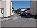
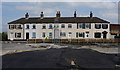
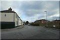
4
Barrowby Lane
A short no through road section of Barrowby Lane.
Image: © DS Pugh
Taken: 18 Mar 2023
0.01 miles
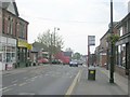
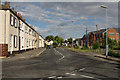
5
Traffic lights on Barrowby Lane
Looking towards the junction with Aberford Road in Garforth.
Image: © DS Pugh
Taken: 18 Mar 2023
0.02 miles
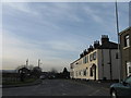
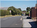
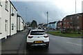
7
Barrowby Lane meets Barwick Road
Barwick Road is to the left with Barrowby Lane ahead and behind.
Image: © DS Pugh
Taken: 11 Feb 2023
0.02 miles