IMAGES TAKEN NEAR TO
Lowther Drive, LEEDS, LS25 1EW
Introduction
This page details the photographs taken nearby to Lowther Drive, LS25 1EW by members of the Geograph project.
The Geograph project started in 2005 with the aim of publishing, organising and preserving representative images for every square kilometre of Great Britain, Ireland and the Isle of Man.

There are currently over 7.5m images from over14,400 individuals and you can help contribute to the project by visiting https://www.geograph.org.uk
Image Map
Images are licensed for reuse under creativecommons.org/licenses/by-sa/2.0
Notes
- Clicking on the map will re-center to the selected point.
- The higher the marker number, the further away the image location is from the centre of the postcode.
Image Listing (92 Images Found)
Images are licensed for reuse under creativecommons.org/licenses/by-sa/2.0
Image
Details
Distance
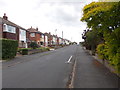
1
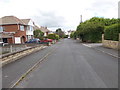
Lowther Drive - looking towards Lowther Road
Image: © Betty Longbottom
Taken: 27 Jun 2016
0.04 miles
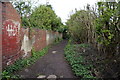
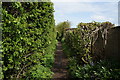
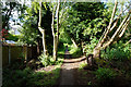
2

Leeds Country Way in Garforth (2)
A straight path between back gardens, before emerging onto the main shopping street in Garforth
Image: © Chris Heaton
Taken: 15 Feb 2019
0.04 miles
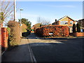
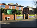
10
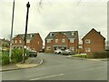
Appletree Court, Lidgett Lane
A small modern housing development.
Image: © Stephen Craven
Taken: 22 Jan 2022
0.11 miles