IMAGES TAKEN NEAR TO
Springbank, LEEDS, LS25 1DD
Introduction
This page details the photographs taken nearby to Springbank, LS25 1DD by members of the Geograph project.
The Geograph project started in 2005 with the aim of publishing, organising and preserving representative images for every square kilometre of Great Britain, Ireland and the Isle of Man.

There are currently over 7.5m images from over14,400 individuals and you can help contribute to the project by visiting https://www.geograph.org.uk
Image Map (Loading...)


Getting Data...Please wait
Leaflet Map data © OpenStreetMap
Images are licensed for reuse under creativecommons.org/licenses/by-sa/2.0
Notes
- Clicking on the map will re-center to the selected point.
- The higher the marker number, the further away the image location is from the centre of the postcode.
Image Listing (55 Images Found)
Images are licensed for reuse under creativecommons.org/licenses/by-sa/2.0
Image
Details
Distance
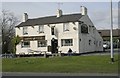
9
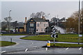
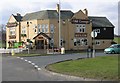
Wet and misty morning at Garforth
The Miller and Carter public house seen across the roundabout.
Image: © David Martin
Taken: 16 Mar 2013
0.12 miles