IMAGES TAKEN NEAR TO
Nanny Lane, TADCASTER, LS24 9RL
Introduction
This page details the photographs taken nearby to Nanny Lane, LS24 9RL by members of the Geograph project.
The Geograph project started in 2005 with the aim of publishing, organising and preserving representative images for every square kilometre of Great Britain, Ireland and the Isle of Man.

There are currently over 7.5m images from over14,400 individuals and you can help contribute to the project by visiting https://www.geograph.org.uk
Image Map
Images are licensed for reuse under creativecommons.org/licenses/by-sa/2.0
Notes
- Clicking on the map will re-center to the selected point.
- The higher the marker number, the further away the image location is from the centre of the postcode.
Image Listing (22 Images Found)
Images are licensed for reuse under creativecommons.org/licenses/by-sa/2.0
Image
Details
Distance
1
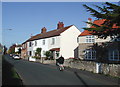
Nanny Lane, Church Fenton
Looking north-northwest along Nanny Lane, with Maple Cottage on the far right of the picture.
Image: © Paul Glazzard
Taken: 6 Nov 2007
0.07 miles
2
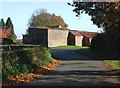
Hall Lane, Church Fenton
Looking east-northeast from Hall Lane towards the barn at Vine Croft on the junction of Nanny Lane and Broad Lane, Church Fenton.
Image: © Paul Glazzard
Taken: 6 Nov 2007
0.14 miles
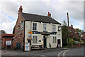
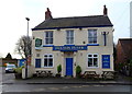
4
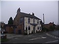
The Fenton Flyer public house
On the corner of Nanny Lane and Main Street
Image: © Tim Glover
Taken: 22 Jan 2017
0.16 miles
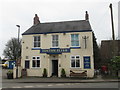
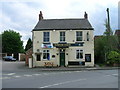
6
Fenton Flyer
Looking along Busk Lane in Church Fenton.
Image: © DS Pugh
Taken: 3 Aug 2013
0.16 miles
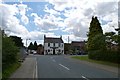
7
The Fenton Flyer
Busk Lane meets Main Street in Church Fenton.
Image: © DS Pugh
Taken: 13 Jun 2021
0.16 miles
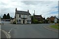
8
The Fenton Flyer, Church Fenton
On Main Street.
Currently to let.
Image: © JThomas
Taken: 8 Feb 2020
0.16 miles