IMAGES TAKEN NEAR TO
Saxton, TADCASTER, LS24 9QQ
Introduction
This page details the photographs taken nearby to LS24 9QQ by members of the Geograph project.
The Geograph project started in 2005 with the aim of publishing, organising and preserving representative images for every square kilometre of Great Britain, Ireland and the Isle of Man.

There are currently over 7.5m images from over14,400 individuals and you can help contribute to the project by visiting https://www.geograph.org.uk
Image Map (Loading...)


Getting Data...Please wait
Leaflet Map data © OpenStreetMap
Images are licensed for reuse under creativecommons.org/licenses/by-sa/2.0
Notes
- Clicking on the map will re-center to the selected point.
- The higher the marker number, the further away the image location is from the centre of the postcode.
Image Listing (22 Images Found)
Images are licensed for reuse under creativecommons.org/licenses/by-sa/2.0
Image
Details
Distance
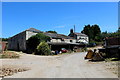
5
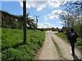
Track at Castle Hill Farm
Looking south-eastward.
Image: © Peter Wood
Taken: 23 Apr 2016
0.04 miles
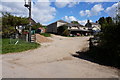
6
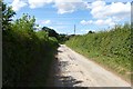
Bridleway to Tadcaster
Near Castle Hill Farm.
Image: © DS Pugh
Taken: 3 Aug 2013
0.05 miles
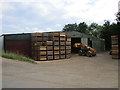
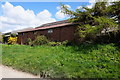
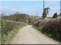
8
Lane to Low Lead Farm
Continues as a bridleway until it meets Chantry Lane.
Castle Hill Farm is on top of the bank to the right.
Image: © Jonathan Thacker
Taken: 8 Jun 2018
0.08 miles
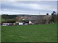
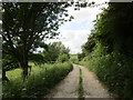
10
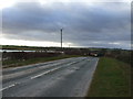
Chantry Lane, Saxton
Seen from the B1217, passing Castle Hill farm on the right. This is near the site of the Battle of Towton, one of the bloodiest battles of the Wars of The Roses, in 1461.
Image: © Rich Tea
Taken: 13 Apr 2006
0.10 miles