IMAGES TAKEN NEAR TO
Street 6, WETHERBY, LS23 7FP
Introduction
This page details the photographs taken nearby to Street 6, LS23 7FP by members of the Geograph project.
The Geograph project started in 2005 with the aim of publishing, organising and preserving representative images for every square kilometre of Great Britain, Ireland and the Isle of Man.

There are currently over 7.5m images from over14,400 individuals and you can help contribute to the project by visiting https://www.geograph.org.uk
Image Map (Loading...)


Getting Data...Please wait
Leaflet Map data © OpenStreetMap
Images are licensed for reuse under creativecommons.org/licenses/by-sa/2.0
Notes
- Clicking on the map will re-center to the selected point.
- The higher the marker number, the further away the image location is from the centre of the postcode.
Image Listing (9 Images Found)
Images are licensed for reuse under creativecommons.org/licenses/by-sa/2.0
Image
Details
Distance
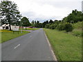
1
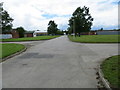
Thorp Arch Trading Estate - Avenue B
Looking south-westward.
Image: © Peter Wood
Taken: 17 Jun 2019
0.13 miles
2
Thorp Arch industrial estate
Situated between Thorp Arch and Walton, this former Royal Ordnance site is now a trading estate. Taken from a bicycle on a very wet afternoon.
Image: © DS Pugh
Taken: 22 Sep 2006
0.17 miles
3
Shops at Thorp Arch
The Thorp Arch trading estate is built on a former Royal Ordnance Factory (ROF). This site produced munitions for WWII and the Korean war, but is long gone and the site is now a trading estate. These are some of the commercial tenants on this site, built into the munitions stores.
Image: © DS Pugh
Taken: 7 Jul 2007
0.17 miles
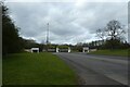
4
Avenue C West at Thorpe Arch
One of the network of roads that criss-cross this industrial site, once the home of a Royal Ordnance factory and storage site.
Image: © Gordon Hatton
Taken: 9 Jul 2023
0.18 miles
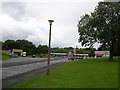
5
Thorp Arch Trading Estate - Street 7
Looking north-westward.
Image: © Peter Wood
Taken: 17 Jun 2019
0.21 miles
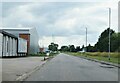
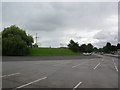
6
Thorp Arch Trading Estate
Once a thriving outlet with numerous stores selling white goods and furniture. Few premises are still occupied. A fence lies across the road here.
Image: © DS Pugh
Taken: 27 Mar 2021
0.21 miles
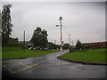
7
Avenue C and Street 7
Looking along Avenue C as it crosses Street 7 at Thorp Arch.
Image: © DS Pugh
Taken: 26 Nov 2017
0.22 miles
8
Pirate ship
The Thorp Arch trading estate is built on a former Royal Ordnance Factory (ROF). This site produced munitions for WWII and the Korean war. For as long as I can remember there has been this pirate ship on the estate near the main commercial sites.
Image: © DS Pugh
Taken: 7 Jul 2007
0.24 miles
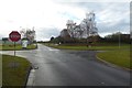
9
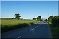
Wighill Lane near Rudgate
Looking along Wighill Lane towards the junction with Rudgate on the edge of Thorp Arch.
Image: © DS Pugh
Taken: 2 Jun 2023
0.25 miles