IMAGES TAKEN NEAR TO
Moat House Square, Avenue E East, WETHERBY, LS23 7FB
Introduction
This page details the photographs taken nearby to Moat House Square, Avenue E East, LS23 7FB by members of the Geograph project.
The Geograph project started in 2005 with the aim of publishing, organising and preserving representative images for every square kilometre of Great Britain, Ireland and the Isle of Man.

There are currently over 7.5m images from over14,400 individuals and you can help contribute to the project by visiting https://www.geograph.org.uk
Image Map (Loading...)


Getting Data...Please wait
Leaflet Map data © OpenStreetMap
Images are licensed for reuse under creativecommons.org/licenses/by-sa/2.0
Notes
- Clicking on the map will re-center to the selected point.
- The higher the marker number, the further away the image location is from the centre of the postcode.
Image Listing (11 Images Found)
Images are licensed for reuse under creativecommons.org/licenses/by-sa/2.0
Image
Details
Distance
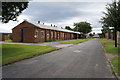
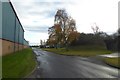
3
Bus stop on Avenue E
Looking along Avenue E at Thorp Arch.
Image: © DS Pugh
Taken: 26 Nov 2017
0.10 miles

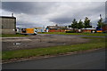
5
DFS Warehouse
On Avenue E E, Thorp Arch Trading Estate.
Image: © Ian S
Taken: 16 Aug 2014
0.13 miles
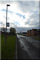
6
Street 7
Looking along Street 7 at Thorp Arch.
Image: © DS Pugh
Taken: 26 Nov 2017
0.15 miles
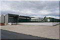
7
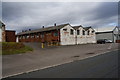
Building 519 on Avenue E E
Thorp Arch Trading Estate.
Image: © Ian S
Taken: 16 Aug 2014
0.17 miles
8
Tracks along the eastern boundary of Thorp Arch Trading Estate
Image: © John Slater
Taken: 11 Mar 2018
0.22 miles
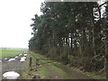
9
Track beside the Eastern Edge of Thorp Arch Trading Estate
Image: © Chris Heaton
Taken: 14 Aug 2018
0.24 miles
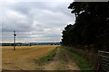
10
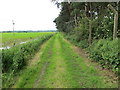
Enclosed grass track beside Thorp Arch Trading Estate and arable field
Looking southward.
Image: © Peter Wood
Taken: 17 Jun 2019
0.24 miles