IMAGES TAKEN NEAR TO
Hall Park Road, WETHERBY, LS23 7DH
Introduction
This page details the photographs taken nearby to Hall Park Road, LS23 7DH by members of the Geograph project.
The Geograph project started in 2005 with the aim of publishing, organising and preserving representative images for every square kilometre of Great Britain, Ireland and the Isle of Man.

There are currently over 7.5m images from over14,400 individuals and you can help contribute to the project by visiting https://www.geograph.org.uk
Image Map
Images are licensed for reuse under creativecommons.org/licenses/by-sa/2.0
Notes
- Clicking on the map will re-center to the selected point.
- The higher the marker number, the further away the image location is from the centre of the postcode.
Image Listing (10 Images Found)
Images are licensed for reuse under creativecommons.org/licenses/by-sa/2.0
Image
Details
Distance
2
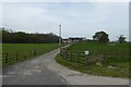
Hall Parks Farm
Looking along the drive towards the farm and wind turbine.
Image: © DS Pugh
Taken: 30 Apr 2017
0.11 miles
3
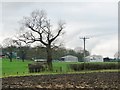
Winter tree at Hall Park
At the junction of three field boundaries.
Image: © Christine Johnstone
Taken: 30 Jan 2017
0.15 miles
4
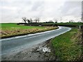
Double bend on Hall Park Road
The road follows the route of the south side of the original park pale [a low fenced embankment along the boundary of a deer park].
Image: © Christine Johnstone
Taken: 30 Jan 2017
0.17 miles
6
Electricity supply infrastructure, Hall Park
The small unit is labelled 'transformer rectifier'. This is equipment which can switch alternating current [AC] to direct current [DC].
Image: © Christine Johnstone
Taken: 30 Jan 2017
0.18 miles
7
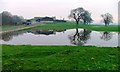
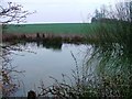
Localised flooding at Hall Park
On the south side of Hall Park Road.
Image: © Christine Johnstone
Taken: 30 Jan 2017
0.19 miles
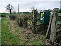
8
Uncultivated field margin, Hall Park
On the north side of Hall Park Road. This is the route of the original park pale [a low fenced embankment along the boundary of a deer park].
Image: © Christine Johnstone
Taken: 30 Jan 2017
0.19 miles
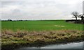
9
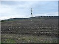
Recently ploughed field, Hall Park
On the horizon, Hall Park Wood.
Image: © Christine Johnstone
Taken: 30 Jan 2017
0.19 miles
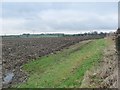
10

Hall Park Road, heading east
Connecting Walton with the Roman road Rudgate, at the north-east tip of Leeds Metropolitan District.
Image: © Christine Johnstone
Taken: 30 Jan 2017
0.19 miles