IMAGES TAKEN NEAR TO
Church Causeway, WETHERBY, LS23 7AE
Introduction
This page details the photographs taken nearby to Church Causeway, LS23 7AE by members of the Geograph project.
The Geograph project started in 2005 with the aim of publishing, organising and preserving representative images for every square kilometre of Great Britain, Ireland and the Isle of Man.

There are currently over 7.5m images from over14,400 individuals and you can help contribute to the project by visiting https://www.geograph.org.uk
Image Map (Loading...)


Getting Data...Please wait
Leaflet Map data © OpenStreetMap
Images are licensed for reuse under creativecommons.org/licenses/by-sa/2.0
Notes
- Clicking on the map will re-center to the selected point.
- The higher the marker number, the further away the image location is from the centre of the postcode.
Image Listing (107 Images Found)
Images are licensed for reuse under creativecommons.org/licenses/by-sa/2.0
Image
Details
Distance
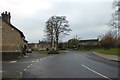
2
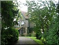
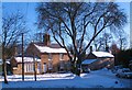
The Old Vicarage - Church Causeway, Thorp Arch
Image: © Betty Longbottom
Taken: 10 Sep 2008
0.05 miles
3
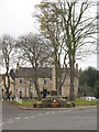
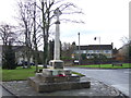
War Memorial and green at Thorp Arch
The green is bisected by the road through the village, with the war memorial on a triangle of green.
Image: © Gordon Hatton
Taken: 22 Nov 2007
0.07 miles

5
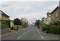
Thorpe Arch village
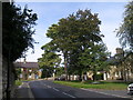
Nineteenth century cottages of local stone under slate roofs at the edge of the green.
Image: © Gordon Hatton
Taken: 8 Dec 2010
0.07 miles
9
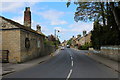
Thorp Arch War Memorial
Looking towards the War Memorial at the junction of Bridge Foot and Church Causeway.
Image: © DS Pugh
Taken: 26 Nov 2017
0.08 miles