IMAGES TAKEN NEAR TO
Albion Terrace, WETHERBY, LS23 6HZ
Introduction
This page details the photographs taken nearby to Albion Terrace, LS23 6HZ by members of the Geograph project.
The Geograph project started in 2005 with the aim of publishing, organising and preserving representative images for every square kilometre of Great Britain, Ireland and the Isle of Man.

There are currently over 7.5m images from over14,400 individuals and you can help contribute to the project by visiting https://www.geograph.org.uk
Image Map
Images are licensed for reuse under creativecommons.org/licenses/by-sa/2.0
Notes
- Clicking on the map will re-center to the selected point.
- The higher the marker number, the further away the image location is from the centre of the postcode.
Image Listing (97 Images Found)
Images are licensed for reuse under creativecommons.org/licenses/by-sa/2.0
Image
Details
Distance
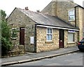
3
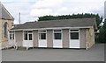
Clifford Methodist Church Hall - Nursery Way
Image: © Betty Longbottom
Taken: 3 Sep 2008
0.05 miles
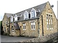
4
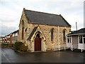
Methodist chapel, Clifford.
Small stone built chapel dated 1855. Oddly situated, being surrounded by modern housing. Presumably when built, it was in a field behind the main street.
Image: © Gordon Hatton
Taken: 22 Nov 2007
0.06 miles
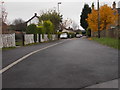
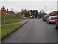
6
Former School - Nursery Way, Clifford
Image: © Betty Longbottom
Taken: 3 Sep 2008
0.06 miles
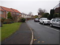
7
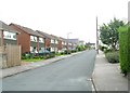
Albion Street - viewed from Moor Avenue
Image: © Betty Longbottom
Taken: 22 Nov 2016
0.06 miles
8
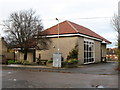
Clifford village hall
Modern community hall in this village.
Image: © Gordon Hatton
Taken: 22 Nov 2007
0.07 miles
10
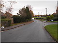
Albion Street - viewed from Moor Avenue
Image: © Betty Longbottom
Taken: 22 Nov 2016
0.07 miles