IMAGES TAKEN NEAR TO
New Mill Lane, WETHERBY, LS23 6HN
Introduction
This page details the photographs taken nearby to New Mill Lane, LS23 6HN by members of the Geograph project.
The Geograph project started in 2005 with the aim of publishing, organising and preserving representative images for every square kilometre of Great Britain, Ireland and the Isle of Man.

There are currently over 7.5m images from over14,400 individuals and you can help contribute to the project by visiting https://www.geograph.org.uk
Image Map (Loading...)


Getting Data...Please wait
Leaflet Map data © OpenStreetMap
Images are licensed for reuse under creativecommons.org/licenses/by-sa/2.0
Notes
- Clicking on the map will re-center to the selected point.
- The higher the marker number, the further away the image location is from the centre of the postcode.
Image Listing (60 Images Found)
Images are licensed for reuse under creativecommons.org/licenses/by-sa/2.0
Image
Details
Distance
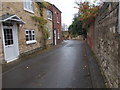
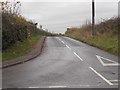
3
High Street, Clifford
Looking along High Street towards the junction with Cinder Lane.
Image: © DS Pugh
Taken: 26 Nov 2017
0.03 miles
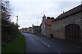
7

St Edward's Catholic Church - High Street, Clifford
Image: © Betty Longbottom
Taken: 3 Sep 2008
0.08 miles
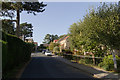
8

St Edward, King and Confessor Roman Catholic Church
Image: © SMJ
Taken: 21 Mar 2010
0.08 miles
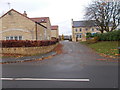
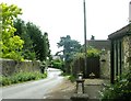
9
Old Mill Lane
Looking towards the junction with Springfield on the left.
Image: © Mark Anderson
Taken: 19 Sep 2020
0.09 miles
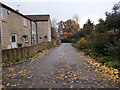
10
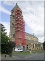
St Edward's Catholic Church - High Street, Clifford
Currently undergoing restoration.
Image: © Betty Longbottom
Taken: 3 Sep 2008
0.09 miles