IMAGES TAKEN NEAR TO
Kings Meadow Drive, WETHERBY, LS22 7FS
Introduction
This page details the photographs taken nearby to Kings Meadow Drive, LS22 7FS by members of the Geograph project.
The Geograph project started in 2005 with the aim of publishing, organising and preserving representative images for every square kilometre of Great Britain, Ireland and the Isle of Man.

There are currently over 7.5m images from over14,400 individuals and you can help contribute to the project by visiting https://www.geograph.org.uk
Image Map (Loading...)


Getting Data...Please wait
Leaflet Map data © OpenStreetMap
Images are licensed for reuse under creativecommons.org/licenses/by-sa/2.0
Notes
- Clicking on the map will re-center to the selected point.
- The higher the marker number, the further away the image location is from the centre of the postcode.
Image Listing (99 Images Found)
Images are licensed for reuse under creativecommons.org/licenses/by-sa/2.0
Image
Details
Distance
1
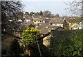
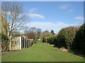
King's Meadow, Wetherby
Housing at Priest Hill seen from the Harland Way, immediately west of the triangle junction shown in Image
Image: © Derek Harper
Taken: 6 Apr 2015
0.02 miles
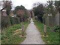
3
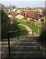
Steps and path from the Harland Way, Wetherby
Leading from the cycle route to the King's Meadow closes on Priest Hill.
Image: © Derek Harper
Taken: 6 Apr 2015
0.04 miles
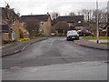
4
Priest Hill, Wetherby
Houses around Ainsty Road, seen from the Harland Way.
Image: © Christine Johnstone
Taken: 8 Apr 2012
0.04 miles
5

Sun setting over the Hudson Way
Looking along the path to Spofforth where the railway once branched.
Image: © DS Pugh
Taken: 14 Apr 2022
0.05 miles
8
The former Wetherby west railway junction
Left for Church Fenton, right for Leeds. Now part of the Harland Way.
Image: © Christine Johnstone
Taken: 8 Apr 2012
0.06 miles
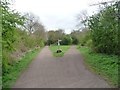
9
Former railway junction, Wetherby
The site of a railway junction on the outskirts of Wetherby, in West Yorkshire. A line branched off to the right, curving round to serve Wetherby station then continuing towards Leeds. To the left, another line continued straight on, avoiding Wetherby station and heading instead to Tadcaster and Church Fenton.
The former railway lines are now open to pedestrians and cyclists. The paths form part of National Cycle Network route 67.
Image: © Malc McDonald
Taken: 14 Oct 2021
0.06 miles
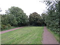
10

Harland Way Junction
See Image; the signpost has gone and the rocks have been replaced by a more comfortable-looking bench. This triangle of grass is at the junction of two former railway lines.
Image: © Derek Harper
Taken: 6 Apr 2015
0.06 miles