IMAGES TAKEN NEAR TO
Sandbeck Way, WETHERBY, LS22 7AD
Introduction
This page details the photographs taken nearby to Sandbeck Way, LS22 7AD by members of the Geograph project.
The Geograph project started in 2005 with the aim of publishing, organising and preserving representative images for every square kilometre of Great Britain, Ireland and the Isle of Man.

There are currently over 7.5m images from over14,400 individuals and you can help contribute to the project by visiting https://www.geograph.org.uk
Image Map (Loading...)


Getting Data...Please wait
Leaflet Map data © OpenStreetMap
Images are licensed for reuse under creativecommons.org/licenses/by-sa/2.0
Notes
- Clicking on the map will re-center to the selected point.
- The higher the marker number, the further away the image location is from the centre of the postcode.
Image Listing (53 Images Found)
Images are licensed for reuse under creativecommons.org/licenses/by-sa/2.0
Image
Details
Distance
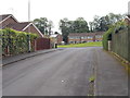
1
Audby Lane - viewed from Sandbeck Way
Image: © Betty Longbottom
Taken: 15 Jun 2016
0.03 miles
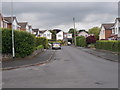
4
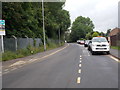
Audby Lane - viewed from Sandbeck Way
Image: © Betty Longbottom
Taken: 15 Jun 2016
0.05 miles
5
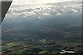
Wetherby to Ingmanthorpe pond: aerial 2016
Pond is in Image
Image: © Chris
Taken: 21 Aug 2016
0.06 miles
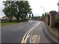
6
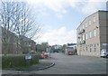
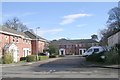
Wetherby & District Social Club - Sandbeck Way
Image: © Betty Longbottom
Taken: 21 Feb 2009
0.06 miles
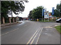
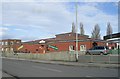
8
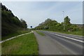
A168 east of Wetherby
Looking along the A168 which runs parallel to the A1(M).
Image: © DS Pugh
Taken: 30 Apr 2017
0.12 miles