IMAGES TAKEN NEAR TO
Durrant Close, WETHERBY, LS22 6RH
Introduction
This page details the photographs taken nearby to Durrant Close, LS22 6RH by members of the Geograph project.
The Geograph project started in 2005 with the aim of publishing, organising and preserving representative images for every square kilometre of Great Britain, Ireland and the Isle of Man.

There are currently over 7.5m images from over14,400 individuals and you can help contribute to the project by visiting https://www.geograph.org.uk
Image Map (400 Images)


Getting Data...Please wait
Leaflet Map data © OpenStreetMap
Images are licensed for reuse under creativecommons.org/licenses/by-sa/2.0
Notes
- Clicking on the map will re-center to the selected point.
- The higher the marker number, the further away the image location is from the centre of the postcode.
Image Listing (400 Images Found)
Images are licensed for reuse under creativecommons.org/licenses/by-sa/2.0
Image
Details
Distance
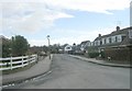
4
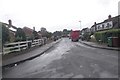
Walton Road - viewed from Heuthwaite Avenue
Image: © Betty Longbottom
Taken: 15 Jun 2016
0.06 miles
6
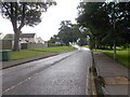
Walton Road - viewed from Heuthwaite Avenue
Image: © Betty Longbottom
Taken: 15 Jun 2016
0.07 miles
7
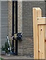
Wetherby, 30 Second Avenue
The benchmark is cut into the gable end of the property and is cut across the 8th and 9th brick courses.
Image: © Mel Towler
Taken: 19 Sep 2022
0.07 miles
8
Wetherby, 30 Second Avenue
There is a benchmark cut into the gable end of the property and is cut across the 8th and 9th brick courses.
Image: © Mel Towler
Taken: 19 Sep 2022
0.07 miles
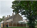
10

Wilderness Car Park, Wetherby
It would be interesting to know the origin of this name. Only three months earlier the car park had been submerged to a depth of several feet in the 2015 Boxing Day floods.
Image: © Stephen Craven
Taken: 25 Mar 2016
0.08 miles