IMAGES TAKEN NEAR TO
Oak Ridge, WETHERBY, LS22 6GT
Introduction
This page details the photographs taken nearby to Oak Ridge, LS22 6GT by members of the Geograph project.
The Geograph project started in 2005 with the aim of publishing, organising and preserving representative images for every square kilometre of Great Britain, Ireland and the Isle of Man.

There are currently over 7.5m images from over14,400 individuals and you can help contribute to the project by visiting https://www.geograph.org.uk
Image Map
Images are licensed for reuse under creativecommons.org/licenses/by-sa/2.0
Notes
- Clicking on the map will re-center to the selected point.
- The higher the marker number, the further away the image location is from the centre of the postcode.
Image Listing (74 Images Found)
Images are licensed for reuse under creativecommons.org/licenses/by-sa/2.0
Image
Details
Distance
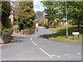
2
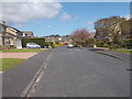
Ullswater Rise - looking towards Ullswater Drive
Image: © Betty Longbottom
Taken: 3 May 2016
0.05 miles
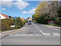
5

Wharfe Grove Gardens - Wharfe Grove
Image: © Betty Longbottom
Taken: 3 May 2016
0.08 miles
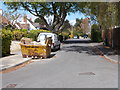
7
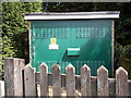
Electricity Substation No 4243 - Wharfe Grove
Image: © Betty Longbottom
Taken: 3 May 2016
0.10 miles
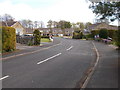
9
Wetherby, bridge over the disused railway
There is a benchmark cut into the southern parapet on Linton Road.
Image: © Mel Towler
Taken: 7 Aug 2022
0.10 miles