IMAGES TAKEN NEAR TO
Bloom Drive, WETHERBY, LS22 6AR
Introduction
This page details the photographs taken nearby to Bloom Drive, LS22 6AR by members of the Geograph project.
The Geograph project started in 2005 with the aim of publishing, organising and preserving representative images for every square kilometre of Great Britain, Ireland and the Isle of Man.

There are currently over 7.5m images from over14,400 individuals and you can help contribute to the project by visiting https://www.geograph.org.uk
Image Map (76 Images)


Getting Data...Please wait
Leaflet Map data © OpenStreetMap
Images are licensed for reuse under creativecommons.org/licenses/by-sa/2.0
Notes
- Clicking on the map will re-center to the selected point.
- The higher the marker number, the further away the image location is from the centre of the postcode.
Image Listing (76 Images Found)
Images are licensed for reuse under creativecommons.org/licenses/by-sa/2.0
Image
Details
Distance
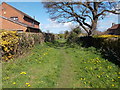
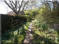
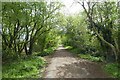
5
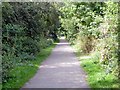
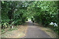
On the Harland Way
A leisure route between Wetherby and Spofforth on the line of the former Harrogate to Church Fenton railway.
Image: © Graham Hogg
Taken: 16 Aug 2016
0.10 miles
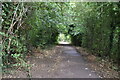
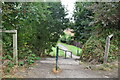
7
Cycle path in Wetherby
Looking along part of route 67 along the former railway line.
Image: © DS Pugh
Taken: 18 Apr 2022
0.11 miles
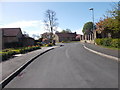
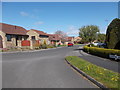
10
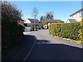
Glebe Field Garth - Glebe Field Drive
Image: © Betty Longbottom
Taken: 3 May 2016
0.14 miles