IMAGES TAKEN NEAR TO
Bridge Court, WETHERBY, LS22 5GZ
Introduction
This page details the photographs taken nearby to Bridge Court, LS22 5GZ by members of the Geograph project.
The Geograph project started in 2005 with the aim of publishing, organising and preserving representative images for every square kilometre of Great Britain, Ireland and the Isle of Man.

There are currently over 7.5m images from over14,400 individuals and you can help contribute to the project by visiting https://www.geograph.org.uk
Image Map (Loading...)


Getting Data...Please wait
Leaflet Map data © OpenStreetMap
Images are licensed for reuse under creativecommons.org/licenses/by-sa/2.0
Notes
- Clicking on the map will re-center to the selected point.
- The higher the marker number, the further away the image location is from the centre of the postcode.
Image Listing (513 Images Found)
Images are licensed for reuse under creativecommons.org/licenses/by-sa/2.0
Image
Details
Distance
1
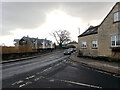
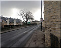
Junction of Lodge Lane and Boston Road (A661), Micklethwaite, Wetherby
Image: © habiloid
Taken: 29 Jan 2022
0.02 miles
2
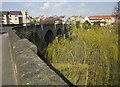
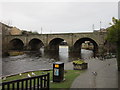
Wetherby Bridge
From the same spot as Image], looking to the left. The bridge is listed and described at http://list.historicengland.org.uk/resultsingle.aspx?uid=1313468&searchtype=mapsearch.
Image: © Derek Harper
Taken: 6 Apr 2015
0.02 miles
4
Wetherby Bridge
Listed ancient monument that used to carry the Great North Road (A1) over the River Wharfe, until a bypass was constructed.
The road has now been renumbered as the A661.
Image: © Chris Heaton
Taken: 11 Oct 2015
0.02 miles
5
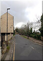
Boston Road (A661), Micklethwaite, Wetherby
Image: © habiloid
Taken: 29 Jan 2022
0.02 miles
7
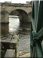
Wetherby Bridge
View from the site of the watermill.
Image: © Alan Murray-Rust
Taken: 5 Dec 2022
0.02 miles
8
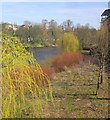
Trees by the Wharfe
On the south bank of the river beside Wetherby Bridge. Two weeping willows with fresh yellowy-green leaves emerging; I guess the red might be dogwood.
Image: © Derek Harper
Taken: 6 Apr 2015
0.03 miles
9
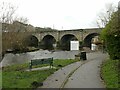
Wetherby Bridge
General view looking west. The bridge has a medieval core, rebuilt in the 17th century, and was widened in 1773 (west side), and 1826 (east side, in view). It is Listed Grade II and also a Scheduled Monument.
Image: © Alan Murray-Rust
Taken: 5 Dec 2022
0.03 miles
10
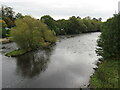
River Wharfe, Wetherby
The River Wharfe flows through the town of Wetherby in West Yorkshire.
Image: © Malc McDonald
Taken: 14 Oct 2021
0.03 miles