IMAGES TAKEN NEAR TO
Carr Lane, WETHERBY, LS22 5EA
Introduction
This page details the photographs taken nearby to Carr Lane, LS22 5EA by members of the Geograph project.
The Geograph project started in 2005 with the aim of publishing, organising and preserving representative images for every square kilometre of Great Britain, Ireland and the Isle of Man.

There are currently over 7.5m images from over14,400 individuals and you can help contribute to the project by visiting https://www.geograph.org.uk
Image Map (Loading...)


Getting Data...Please wait
Leaflet Map data © OpenStreetMap
Images are licensed for reuse under creativecommons.org/licenses/by-sa/2.0
Notes
- Clicking on the map will re-center to the selected point.
- The higher the marker number, the further away the image location is from the centre of the postcode.
Image Listing (5 Images Found)
Images are licensed for reuse under creativecommons.org/licenses/by-sa/2.0
Image
Details
Distance
1
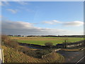
Wetherby racecourse from the York Road bridge over the A1(M)
Image: © John Slater
Taken: 25 Dec 2019
0.22 miles
2
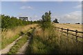
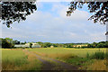
Bridleway to Sandbeck Wood
The A1(M) road is on the other side of the hedge to the left.
Image: © Mark Anderson
Taken: 24 Aug 2018
0.23 miles
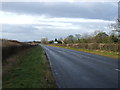
4
Bridleway alongside the motorway at Wetherby
Image: © John Slater
Taken: 8 Nov 2012
0.24 miles
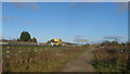
5
Footpath leading to HM Young Offender Institution
The footpath heads across a field, before following the perimeter fence of the Young Offender Institution
Image: © Chris Heaton
Taken: 14 Aug 2018
0.25 miles