
IMAGES TAKEN NEAR TO
Birdale Field Lane, WETHERBY, LS22 5DT
Introduction
This page details the photographs taken nearby to Birdale Field Lane, LS22 5DT by members of the Geograph project.
The Geograph project started in 2005 with the aim of publishing, organising and preserving representative images for every square kilometre of Great Britain, Ireland and the Isle of Man.

There are currently over 7.5m images from over14,400 individuals and you can help contribute to the project by visiting https://www.geograph.org.uk
Image Map
Images are licensed for reuse under creativecommons.org/licenses/by-sa/2.0
Notes
- Clicking on the map will re-center to the selected point.
- The higher the marker number, the further away the image location is from the centre of the postcode.
Image Listing (12 Images Found)
Images are licensed for reuse under creativecommons.org/licenses/by-sa/2.0
Image
Details
Distance
2

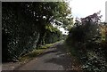
Fields north of Wattle Syke
The A659 here forms the parish boundary between Collingham and Wetherby; the fields seen here are on the Wetherby side.
Image: © Stephen Craven
Taken: 10 Jun 2023
0.21 miles
3
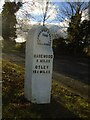
Old milestone
The left face of the WRCC milestone on the south side of the A659 Wattlesyke. It is at the Birdale Field Lane junction (No Through Road) near a sign saying THE HAT BOX. 615 of these milestones were erected in 1893/94 by the West Riding County Council. More than half can still be found all over the old West Riding parts of which are now in Cumbria and Greater Manchester. An inscribed bench mark is on the left side of the stone.
Image: © Chris Minto
Taken: 21 Nov 2021
0.21 miles
4
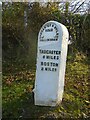
Old milestone
The right-hand face of the stone on Wattlesyke, A659, at the Birdale Field Lane junction. This milestone was painted in 2004 and 2011 and may have been freshened up since then.
Image: © Chris Minto
Taken: 21 Nov 2021
0.21 miles
5
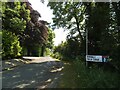
Birdale Field Lane
As a tarmac road this only leads to one farm, beyond which it becomes a footpath to Moor Lane.
Image: © Stephen Craven
Taken: 10 Jun 2023
0.22 miles
6
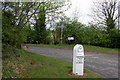
Milestone, Wattle Syke
Milestone on Wattle Syke at the junction with Birdale Field Lane. The milestone has a bench mark cut into it and a closer view can be seen here: Image
Image: © Mark Anderson
Taken: 28 Apr 2010
0.23 miles
7
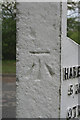
Bench Marked Milestone, Wattle Syke
A close-up view of the bench mark on this milestone. Bench Mark Database: http://www.bench-marks.org.uk/bm34161
Image: © Mark Anderson
Taken: 28 Apr 2010
0.23 miles
8
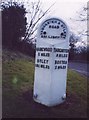
Old Milestone by the A659, Harewood Road, Wattlesyke
Milestone by the A659, in parish of Collingham (Leeds District), Harewood Road, between A58 and A1, Wattlesyke, at Birdale Field Lane, on grass verge.
Inscription reads:-
: HAREWOOD / 5 MILES / OTLEY / 13¼ MILES : : TADCASTER & OTLEY / ROAD / COLLINGHAM : : TADCASTER / 6 MILES / BOSTON / 2 MILES :
Milestone Society National ID: YW_TCOT06
Image: © Milestone Society
Taken: Unknown
0.23 miles
9
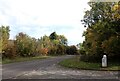
The junction of Birdale Field Lane and Wattle Syke (A659), Collingham
A close-up of the milestone can be seen in Image
Image: © habiloid
Taken: 9 Oct 2022
0.23 miles
10
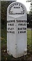
Milestone, Wattle Syke (A659), Collingham
The milestone is at the junction of Wattle Syke with Birdale Field Lane. It can be seen in context in Image It reads:
"TADCASTER & OTLEY
ROAD
COLLINGHAM
HAREWOOD
5 MILES
OTLEY
13¼ MILES
TADCASTER
6 MILES
BOSTON
2 MILES".
Image: © habiloid
Taken: 9 Oct 2022
0.23 miles