IMAGES TAKEN NEAR TO
Stockeld Lane, WETHERBY, LS22 4UA
Introduction
This page details the photographs taken nearby to Stockeld Lane, LS22 4UA by members of the Geograph project.
The Geograph project started in 2005 with the aim of publishing, organising and preserving representative images for every square kilometre of Great Britain, Ireland and the Isle of Man.

There are currently over 7.5m images from over14,400 individuals and you can help contribute to the project by visiting https://www.geograph.org.uk
Image Map
Images are licensed for reuse under creativecommons.org/licenses/by-sa/2.0
Notes
- Clicking on the map will re-center to the selected point.
- The higher the marker number, the further away the image location is from the centre of the postcode.
Image Listing (58 Images Found)
Images are licensed for reuse under creativecommons.org/licenses/by-sa/2.0
Image
Details
Distance
1
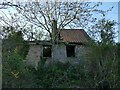
Derelict building, Stockeld Lane, Sicklinghall
Presumably it was part of the former dairy farm Image but looks likely to be demolished when the land is redeveloped.
Image: © Stephen Craven
Taken: 3 Apr 2021
0.01 miles
2
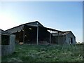
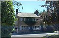
Former Dairy Farm, Stockeld Lane, Sicklinghall
This is shown as "Dairy Farm" on both old and present-day maps, which suggests it's a name rather than just a description. It would appear that farming has now ceased, and indeed the farmhouse was recently on the market for potential residential conversion at a guide price of £1.5 million including 1¾ acres (0.75ha) of land.
Image: © Stephen Craven
Taken: 3 Apr 2021
0.01 miles
3
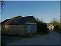
Old building on Stockeld Lane, Sicklinghall
Part of a (former?) dairy farm.
Image: © Stephen Craven
Taken: 3 Apr 2021
0.03 miles
4
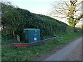
Gas installation, Stockeld Lane, Sicklinghall
Image: © Stephen Craven
Taken: 3 Apr 2021
0.03 miles
5
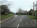
Junction of Stockeld Lane and the Wetherby Road
At the east end of Sicklinghall's Main Street.
Image: © Christine Johnstone
Taken: 26 Nov 2020
0.04 miles
6
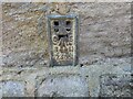
Sicklinghall, Pear Tree Cottage
The OS Flush Bracket 2365 is embedded into the north facing wall of the cottage.
Image: © Mel Towler
Taken: 13 Aug 2022
0.04 miles
7
Sicklinghall, Pear Tree Cottage
There is OS Flush Bracket 2365 embedded into the north facing wall of the cottage.
Image: © Mel Towler
Taken: 13 Aug 2022
0.05 miles
8
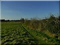
Start of the footpath from Sicklinghall to Spofforth
For two miles I had this footpath to myself on a perfect spring evening.
Image: © Stephen Craven
Taken: 3 Apr 2021
0.06 miles
9
Sicklinghall Millennium oak
A plaque indicates this red oak was planted in 2000.
Image: © Stephen Craven
Taken: 3 Apr 2021
0.06 miles
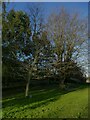
10

The Green, Sicklinghall
At the eastern end of Main Street. The plaque in front of the nearer tree reads 'Red Oak 2000'.
Image: © Christine Johnstone
Taken: 26 Nov 2020
0.06 miles