IMAGES TAKEN NEAR TO
St. Peters Close, WETHERBY, LS22 4FA
Introduction
This page details the photographs taken nearby to St. Peters Close, LS22 4FA by members of the Geograph project.
The Geograph project started in 2005 with the aim of publishing, organising and preserving representative images for every square kilometre of Great Britain, Ireland and the Isle of Man.

There are currently over 7.5m images from over14,400 individuals and you can help contribute to the project by visiting https://www.geograph.org.uk
Image Map (Loading...)


Getting Data...Please wait
Leaflet Map data © OpenStreetMap
Images are licensed for reuse under creativecommons.org/licenses/by-sa/2.0
Notes
- Clicking on the map will re-center to the selected point.
- The higher the marker number, the further away the image location is from the centre of the postcode.
Image Listing (76 Images Found)
Images are licensed for reuse under creativecommons.org/licenses/by-sa/2.0
Image
Details
Distance
1
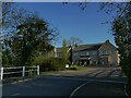
St Peter's Close, Sicklinghall
A modern housing development on the western edge of the village.
Image: © Stephen Craven
Taken: 3 Apr 2021
0.01 miles
2
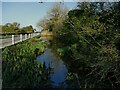
High Flush, Sicklinghall
One of two ponds at opposite ends of the village, the other unsurprisingly being Low Flush Image
Image: © Stephen Craven
Taken: 3 Apr 2021
0.02 miles
3
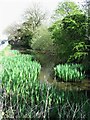
Roadside pond, Sicklinghall
Near the western end of the village and full of tadpoles.
Image: © Gordon Hatton
Taken: 18 Apr 2022
0.02 miles

5
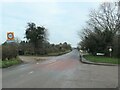
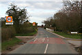
Entering Sicklinghall from the west
A complex set of junctions and then a school.
Image: © Christine Johnstone
Taken: 26 Nov 2020
0.03 miles
6
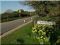
Entering Sicklinghall from the west
The village name sign is opposite Park Lane.
Image: © Stephen Craven
Taken: 3 Apr 2021
0.04 miles

9
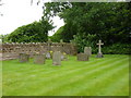
St Peter's Church, Sicklinghall, Graveyard
Image: © Alexander P Kapp
Taken: 10 Jun 2010
0.05 miles
10

Sicklinghall Primary School
Under the control of North Yorkshire CC, but the boundary with Leeds Metropolitan District is only half a mile east of the village. I wonder where children go for secondary education - one assumes into Harrogate.
Image: © Gordon Hatton
Taken: 18 Apr 2022
0.05 miles