IMAGES TAKEN NEAR TO
Sicklinghall, WETHERBY, LS22 4AT
Introduction
This page details the photographs taken nearby to LS22 4AT by members of the Geograph project.
The Geograph project started in 2005 with the aim of publishing, organising and preserving representative images for every square kilometre of Great Britain, Ireland and the Isle of Man.

There are currently over 7.5m images from over14,400 individuals and you can help contribute to the project by visiting https://www.geograph.org.uk
Image Map
Images are licensed for reuse under creativecommons.org/licenses/by-sa/2.0
Notes
- Clicking on the map will re-center to the selected point.
- The higher the marker number, the further away the image location is from the centre of the postcode.
Image Listing (73 Images Found)
Images are licensed for reuse under creativecommons.org/licenses/by-sa/2.0
Image
Details
Distance
1
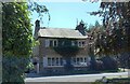
Sicklinghall, Pear Tree Cottage
There is OS Flush Bracket 2365 embedded into the north facing wall of the cottage.
Image: © Mel Towler
Taken: 13 Aug 2022
0.01 miles
2
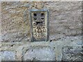
Sicklinghall, Pear Tree Cottage
The OS Flush Bracket 2365 is embedded into the north facing wall of the cottage.
Image: © Mel Towler
Taken: 13 Aug 2022
0.01 miles
3
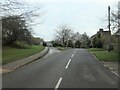
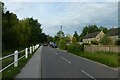
Junction of Stockeld Lane and the Wetherby Road
At the east end of Sicklinghall's Main Street.
Image: © Christine Johnstone
Taken: 26 Nov 2020
0.02 miles
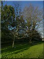
4

The Green, Sicklinghall
At the eastern end of Main Street. The plaque in front of the nearer tree reads 'Red Oak 2000'.
Image: © Christine Johnstone
Taken: 26 Nov 2020
0.02 miles
5
Sicklinghall Millennium oak
A plaque indicates this red oak was planted in 2000.
Image: © Stephen Craven
Taken: 3 Apr 2021
0.02 miles
6
Passing the pond
Looking along Main Street in Sicklinghall.
Image: © DS Pugh
Taken: 5 Jun 2021
0.02 miles
7
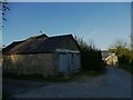
Old building on Stockeld Lane, Sicklinghall
Part of a (former?) dairy farm.
Image: © Stephen Craven
Taken: 3 Apr 2021
0.03 miles
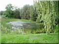
9
![Low Flush [the village pond], Sicklinghall](https://s2.geograph.org.uk/geophotos/06/69/19/6691934_18a57e4e_120x120.jpg)
Low Flush [the village pond], Sicklinghall
According to a nearby notice, on common land. Named as 'Low Flush' on the 1888 large-scale OS map. High Flush was another rectangular pond at the western end of the village.
Image: © Christine Johnstone
Taken: 26 Nov 2020
0.04 miles
10
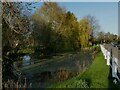
Low Flush, Sicklinghall
One of two ponds at opposite ends of the village, the other unsurprisingly being High Flush Image See also Image
Image: © Stephen Craven
Taken: 3 Apr 2021
0.04 miles