IMAGES TAKEN NEAR TO
Union Court, OTLEY, LS21 3NW
Introduction
This page details the photographs taken nearby to Union Court, LS21 3NW by members of the Geograph project.
The Geograph project started in 2005 with the aim of publishing, organising and preserving representative images for every square kilometre of Great Britain, Ireland and the Isle of Man.

There are currently over 7.5m images from over14,400 individuals and you can help contribute to the project by visiting https://www.geograph.org.uk
Image Map
Images are licensed for reuse under creativecommons.org/licenses/by-sa/2.0
Notes
- Clicking on the map will re-center to the selected point.
- The higher the marker number, the further away the image location is from the centre of the postcode.
Image Listing (281 Images Found)
Images are licensed for reuse under creativecommons.org/licenses/by-sa/2.0
Image
Details
Distance
1

Another yellow bike
Showing the way to the Tour de France cyclists in 2014. This one is chained to a gate and looking a bit sorry for itself six months on from the Tour!
Image: © John Winder
Taken: 30 Dec 2014
0.03 miles
3
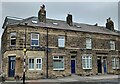
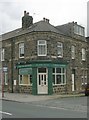
Old Masons Arms and Fleece Pubs in Otley
Another view of the old Masons Arms (the building to the right with 6 windows and a door) from Piper Lane, Otley. History can be found here: http://www.otleypubclub.co.uk/otley-pubs-past/the-masons-arms.
The Fleece pub can also be seen here on the left. This pub is still open, it dates back to at least the 1800's and was originally known as the Golden Fleece. The "Golden" part of the name was dropped in 1861.
Image: © Les
Taken: 16 Mar 2015
0.04 miles
4

Old Masons Arms, Otley
The Masons Arms was an Otley pub from 1840 onwards. Prior to that the Skinners Arms was on this site, probably serving some of the workers at the Skinners plant which was then in operation on the site of Ackroyds mill which is about 1/4 mile away on the riverside. The Masons Arms was on a busy junction between Westgate, Ilkley Road and Pipers Lane (Bradford Road). The Masons Arms closed in 1981 and the building is now a private dwelling. See the link below for more history:-
http://www.otleypubclub.co.uk/otley-pubs-past/the-masons-arms
Image: © Les
Taken: 30 Dec 2014
0.05 miles
5
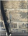
Otley, 55 Westgate
The benchmark is cut into the south face of 55 Westgate, which is on the north side of the road.
Image: © Mel Towler
Taken: 22 Jul 2022
0.05 miles
6
Otley, 55 Westgate
There is a benchmark cut into the south face of 55 Westgate, which is on the north side of the road. It is slightly to the right of the black drainpipe.
Image: © Mel Towler
Taken: 22 Jul 2022
0.05 miles
7

Electricity Substation No 1395 - Granville Mount
Image: © Betty Longbottom
Taken: 2 Sep 2013
0.05 miles

10
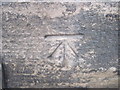
Ordnance Survey Cut Mark
This mark can be found on 55 Westgate.
For more details see : http://www.bench-marks.org.uk/bm41350
Image: © Peter Wood
Taken: 13 Feb 2012
0.05 miles