IMAGES TAKEN NEAR TO
West Busk Lane, OTLEY, LS21 3NB
Introduction
This page details the photographs taken nearby to West Busk Lane, LS21 3NB by members of the Geograph project.
The Geograph project started in 2005 with the aim of publishing, organising and preserving representative images for every square kilometre of Great Britain, Ireland and the Isle of Man.

There are currently over 7.5m images from over14,400 individuals and you can help contribute to the project by visiting https://www.geograph.org.uk
Image Map
Images are licensed for reuse under creativecommons.org/licenses/by-sa/2.0
Notes
- Clicking on the map will re-center to the selected point.
- The higher the marker number, the further away the image location is from the centre of the postcode.
Image Listing (47 Images Found)
Images are licensed for reuse under creativecommons.org/licenses/by-sa/2.0
Image
Details
Distance
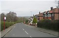
1
West Busk Lane - viewed from Maylea Drive
Image: © Betty Longbottom
Taken: 2 Sep 2013
0.02 miles
3
Maylea Drive - looking towards West Buck Lane
Image: © Betty Longbottom
Taken: 2 Sep 2013
0.04 miles
4
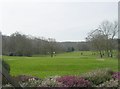
Otley Golf Course - West Busk Lane
Image: © Betty Longbottom
Taken: 16 Mar 2009
0.05 miles
6
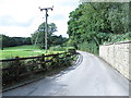
Driveway to Otley Golf Club - West Busk Lane
Image: © Betty Longbottom
Taken: 2 Sep 2013
0.07 miles
7
Prestwick Close - looking towards West Busk Lane
Image: © Betty Longbottom
Taken: 2 Sep 2013
0.08 miles
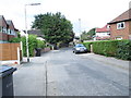
8
Otley, 298 Bradford Road
There is a benchmark cut on the north-east facing wall of the cream coloured house. The cutmark is to the right of the drainpipe and cut into the brickwork.
Image: © Mel Towler
Taken: 12 Aug 2022
0.08 miles