IMAGES TAKEN NEAR TO
West Chevin Road, OTLEY, LS21 3LA
Introduction
This page details the photographs taken nearby to West Chevin Road, LS21 3LA by members of the Geograph project.
The Geograph project started in 2005 with the aim of publishing, organising and preserving representative images for every square kilometre of Great Britain, Ireland and the Isle of Man.

There are currently over 7.5m images from over14,400 individuals and you can help contribute to the project by visiting https://www.geograph.org.uk
Image Map
Images are licensed for reuse under creativecommons.org/licenses/by-sa/2.0
Notes
- Clicking on the map will re-center to the selected point.
- The higher the marker number, the further away the image location is from the centre of the postcode.
Image Listing (129 Images Found)
Images are licensed for reuse under creativecommons.org/licenses/by-sa/2.0
Image
Details
Distance
1
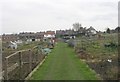
Burras House Allotments - West Chevin Road
Image: © Betty Longbottom
Taken: 16 Mar 2009
0.02 miles
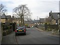
3
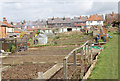
Burras House Allotments, Otley
Planted and waiting for the crops to show.
Image: © John Sparshatt
Taken: 6 Apr 2008
0.03 miles
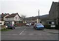
5
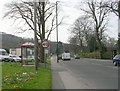
Bradford Road - viewed from West Chevin Road
Image: © Betty Longbottom
Taken: 16 Mar 2009
0.03 miles

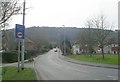
8
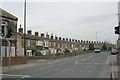
Bradford Road - viewed from West Chevin road
Image: © Betty Longbottom
Taken: 16 Mar 2009
0.04 miles
9
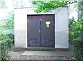
Electricity Substation No 4347 - Grove Hill Park
Image: © Betty Longbottom
Taken: 2 Sep 2013
0.05 miles
