IMAGES TAKEN NEAR TO
Birdcage Court, OTLEY, LS21 3HH
Introduction
This page details the photographs taken nearby to Birdcage Court, LS21 3HH by members of the Geograph project.
The Geograph project started in 2005 with the aim of publishing, organising and preserving representative images for every square kilometre of Great Britain, Ireland and the Isle of Man.

There are currently over 7.5m images from over14,400 individuals and you can help contribute to the project by visiting https://www.geograph.org.uk
Image Map (Loading...)


Getting Data...Please wait
Leaflet Map data © OpenStreetMap
Images are licensed for reuse under creativecommons.org/licenses/by-sa/2.0
Notes
- Clicking on the map will re-center to the selected point.
- The higher the marker number, the further away the image location is from the centre of the postcode.
Image Listing (81 Images Found)
Images are licensed for reuse under creativecommons.org/licenses/by-sa/2.0
Image
Details
Distance
1
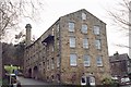
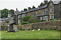
Silver Mill on the edge of Otley
The problem with trying to find out the history of old buildings via Google is that the search engines seem to assume that all anyone is interested in is house prices. I've just spent five minutes searching for "Silver Mill Otley", "Silver Mill Otley History" and "Old Mill Otley" and all sorts of other combinations, and all I discovered was how much it would cost me to buy a flat here. So I have no idea what this mill was used for in its prime, but at a guess I'd say textiles. Nowadays it's divided into flats which command a view over Otley from the foothills of the Chevin.
Image: © John Winder
Taken: 30 Dec 2014
0.01 miles
2
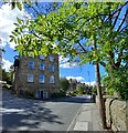
Otley, Birdcage Court
There is a benchmark is cut into the extreme right of the north east face of the old mill building. The building is now called Birdcage Court and has been converted into apartments.
Image: © Mel Towler
Taken: 1 Sep 2022
0.01 miles
3

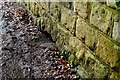
Otley, Birdcage Court
The benchmark is cut into the north east face of the old mill building. The building is now called Birdcage Court and has been converted into apartments.
Image: © Mel Towler
Taken: 1 Sep 2022
0.01 miles
4
Cottages on Chevin Side
Looking towards some houses underneath the Chevin.
Image: © DS Pugh
Taken: 2 Apr 2021
0.04 miles
5
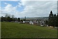
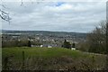
View over Chevin Side
View from the path climbing from Otley towards The Chevin.
Image: © David Martin
Taken: 24 Jun 2022
0.05 miles
7
Remains of small bridge
This is a closer view of the remains of the small bridge which once carried the footpath over a stream running off Otley Chevin. See my previous photo submitted about 10 minutes ago.
Image: © Les
Taken: 11 Mar 2018
0.06 miles
8
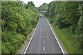
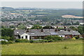
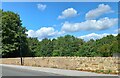
A660 south of Otley
Road constructed on former railway route: this would have been the site of Otley Station. Historic OS mapping shows sidings here on both sides of the through lines. Behind the photographer were further sidings and a goods shed.
Image: © David Martin
Taken: 24 Jun 2022
0.06 miles
9
Below Johnny Lane
Looking down towards Chevin Side.
Image: © DS Pugh
Taken: 2 Apr 2021
0.07 miles
10
Otley, Birdcage Walk
There is a benchmark cut into a 2nd course stone of the roadside wall on the north side of Birdcage Walk.
Image: © Mel Towler
Taken: 1 Sep 2022
0.07 miles