IMAGES TAKEN NEAR TO
Castley Lane, OTLEY, LS21 2PZ
Introduction
This page details the photographs taken nearby to Castley Lane, LS21 2PZ by members of the Geograph project.
The Geograph project started in 2005 with the aim of publishing, organising and preserving representative images for every square kilometre of Great Britain, Ireland and the Isle of Man.

There are currently over 7.5m images from over14,400 individuals and you can help contribute to the project by visiting https://www.geograph.org.uk
Image Map
Images are licensed for reuse under creativecommons.org/licenses/by-sa/2.0
Notes
- Clicking on the map will re-center to the selected point.
- The higher the marker number, the further away the image location is from the centre of the postcode.
Image Listing (23 Images Found)
Images are licensed for reuse under creativecommons.org/licenses/by-sa/2.0
Image
Details
Distance
1
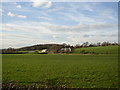
Ings Farm, Castley
A relatively new farm, not on the 1850 map, on which the field in the foreground is named 'The Ings'.
Image: © Humphrey Bolton
Taken: 14 Mar 2007
0.04 miles
2
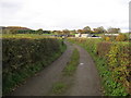
Access Lane to Ings Farm
Farming operation near Castley.
Image: © Chris Heaton
Taken: 12 Nov 2008
0.04 miles
3
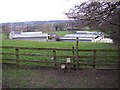
Stile near Ings Farm, Castley
This is on the footpath that goes from Harrogate Road via Ings Farm (in the middle distance) to Castley Lane. The latter part was called Badger Lane on the 1850 map.
Image: © Humphrey Bolton
Taken: 14 Mar 2007
0.05 miles
4
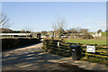
Ings Farm, Castley
Viewed from Castley Lane
Image: © Mark Anderson
Taken: 28 Feb 2021
0.08 miles
5
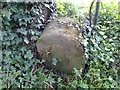
Old Boundary Marker south of Ings Farm, Castley parish
Parish Boundary Marker in parish of Castley (Harrogate District), Ings Farm, Castley Lane, by the riverside.
Grade II listed.
List Entry Number: 1268304 https://historicengland.org.uk/listing/the-list/list-entry/1268304
Surveyed
Milestone Society National ID: YW_KF07pb
Image: © Milestone Society
Taken: Unknown
0.11 miles
6
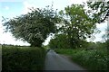
Along Castley Lane
Looking along the road leading to Castley, mostly running on the north bank of the River Wharfe.
Image: © DS Pugh
Taken: 5 Jun 2021
0.12 miles
7
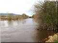
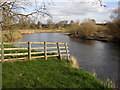
The Wharfe at Castley
Running fast, deep and brown after a weekend of heavy rains in the dales, the River Wharfe looks rather uninviting in this midwinter picture.
Image: © Gordon Hatton
Taken: 12 Jan 2009
0.13 miles
9
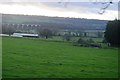
The River Wharfe, Castley
Here a ford used to cross the river on a long diagonal, reaching the Arthington side somewhere near to inside of the bend in the river. No sign of it now.
Image: © Humphrey Bolton
Taken: 14 Mar 2007
0.15 miles
10
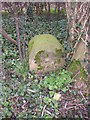
Boundary stone, Castley Lane, Castley
Apparently this is inscribed '1767, K F', although all that can be seen now is a possible '7'. It marks the boundary of Knaresborough Forest. The boundary is marked on the 1850 6” map with the comment 'Perambulated in 1767'.
Image: © Humphrey Bolton
Taken: 14 Mar 2007
0.15 miles