IMAGES TAKEN NEAR TO
Low Snowdon, OTLEY, LS21 2NG
Introduction
This page details the photographs taken nearby to Low Snowdon, LS21 2NG by members of the Geograph project.
The Geograph project started in 2005 with the aim of publishing, organising and preserving representative images for every square kilometre of Great Britain, Ireland and the Isle of Man.

There are currently over 7.5m images from over14,400 individuals and you can help contribute to the project by visiting https://www.geograph.org.uk
Image Map
Images are licensed for reuse under creativecommons.org/licenses/by-sa/2.0
Notes
- Clicking on the map will re-center to the selected point.
- The higher the marker number, the further away the image location is from the centre of the postcode.
Image Listing (8 Images Found)
Images are licensed for reuse under creativecommons.org/licenses/by-sa/2.0
Image
Details
Distance
1
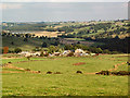
Low Snowden and Washburn Farm
Looking northeastwards from Snowden Carr Road. Swinsty Reservoir beyond.
Image: © David Spencer
Taken: 5 Oct 2005
0.04 miles
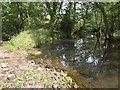
2
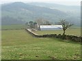
Looking east to Carr Farm
Located below Snowden Carr, above the River Washburn.
Image: © Christine Johnstone
Taken: 17 Mar 2015
0.20 miles
4
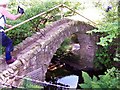
Arthur Adamson Memorial Bridge across Timble Gill Beck
Image: © Joe Regan
Taken: 31 May 2004
0.23 miles
5
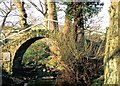
The Arthur Adamson Memorial Bridge - Dob Park
Built in 1967 by his friends in the Ramblers Association the bridge spans Timble Gill Beck as it enters the river Washburn just south of Swinsty Reservoir
Image: © Hugh Chappell
Taken: Unknown
0.23 miles
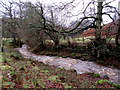
6
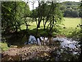
River Washburn at Timble Beck confluence
The stony spit between the watercourses shown in Image, seen from above on footpath 15 6/34/2. High Wood is across the valley.
Image: © Derek Harper
Taken: 28 Jul 2011
0.24 miles
7
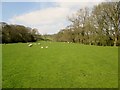
Sheep and Lambs on riverside pasture
Route of the Six Dales Trail the trees to the right mark the bank of the River Washburn
Image: © Martin Dawes
Taken: 20 Apr 2015
0.24 miles
8
River Washburn at Timble Beck confluence
Looking up the river on the right, with the beck on the left. The stony spit between the two helps provide a river crossing if the water level is fairly low.
Image: © Derek Harper
Taken: 28 Jul 2011
0.24 miles