IMAGES TAKEN NEAR TO
Weston Drive, OTLEY, LS21 2DG
Introduction
This page details the photographs taken nearby to Weston Drive, LS21 2DG by members of the Geograph project.
The Geograph project started in 2005 with the aim of publishing, organising and preserving representative images for every square kilometre of Great Britain, Ireland and the Isle of Man.

There are currently over 7.5m images from over14,400 individuals and you can help contribute to the project by visiting https://www.geograph.org.uk
Image Map
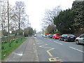
Images are licensed for reuse under creativecommons.org/licenses/by-sa/2.0
Notes
- Clicking on the map will re-center to the selected point.
- The higher the marker number, the further away the image location is from the centre of the postcode.
Image Listing (54 Images Found)
Images are licensed for reuse under creativecommons.org/licenses/by-sa/2.0
Image
Details
Distance
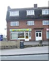
3
Weston General Stores - Weston Drive
Image: © Betty Longbottom
Taken: 31 Mar 2014
0.03 miles
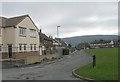
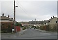
6
Bickerton Way, Otley
Looking north-eastward. The hillside in the distance is about to change for ever - a new housing estate is under construction and likely to be completed by early 2020.
Image: © Peter Wood
Taken: 4 Jul 2018
0.06 miles

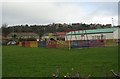
9
Weston Lane - viewed from Ashfield Primary School
Image: © Betty Longbottom
Taken: 31 Mar 2014
0.07 miles