IMAGES TAKEN NEAR TO
Weston Lane, OTLEY, LS21 2DF
Introduction
This page details the photographs taken nearby to Weston Lane, LS21 2DF by members of the Geograph project.
The Geograph project started in 2005 with the aim of publishing, organising and preserving representative images for every square kilometre of Great Britain, Ireland and the Isle of Man.

There are currently over 7.5m images from over14,400 individuals and you can help contribute to the project by visiting https://www.geograph.org.uk
Image Map
Images are licensed for reuse under creativecommons.org/licenses/by-sa/2.0
Notes
- Clicking on the map will re-center to the selected point.
- The higher the marker number, the further away the image location is from the centre of the postcode.
Image Listing (69 Images Found)
Images are licensed for reuse under creativecommons.org/licenses/by-sa/2.0
Image
Details
Distance
1
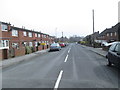
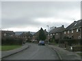
Weston Drive - viewed from Wilkinson Way
Image: © Betty Longbottom
Taken: 31 Mar 2014
0.04 miles
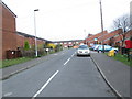
2
Weston Drive - viewed from Wilkinson Way
Image: © Betty Longbottom
Taken: 31 Mar 2014
0.04 miles
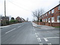
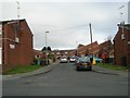
4

Little Green Frog Day Nursery - Weston Lane
Image: © Betty Longbottom
Taken: 31 Mar 2014
0.05 miles
5
Weston Lane - viewed from Ashfield Primary School
Image: © Betty Longbottom
Taken: 31 Mar 2014
0.06 miles
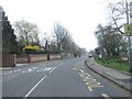
8
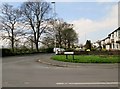
Junction of Weston Drive and Weston Lane
The Six Dales Trail Goes Up Weston Drive on its way out of Newall
Image: © Martin Dawes
Taken: 20 Apr 2015
0.08 miles
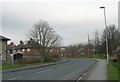
10

Ashfield Primary School - Weston Lane
Image: © Betty Longbottom
Taken: 31 Mar 2014
0.08 miles