IMAGES TAKEN NEAR TO
Riverdale Court, OTLEY, LS21 1SU
Introduction
This page details the photographs taken nearby to Riverdale Court, LS21 1SU by members of the Geograph project.
The Geograph project started in 2005 with the aim of publishing, organising and preserving representative images for every square kilometre of Great Britain, Ireland and the Isle of Man.

There are currently over 7.5m images from over14,400 individuals and you can help contribute to the project by visiting https://www.geograph.org.uk
Image Map
Images are licensed for reuse under creativecommons.org/licenses/by-sa/2.0
Notes
- Clicking on the map will re-center to the selected point.
- The higher the marker number, the further away the image location is from the centre of the postcode.
Image Listing (426 Images Found)
Images are licensed for reuse under creativecommons.org/licenses/by-sa/2.0
Image
Details
Distance
4
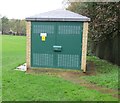
Electricity Substation No 1671 - Riverdale Road
Image: © Betty Longbottom
Taken: 6 Nov 2013
0.06 miles
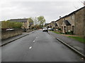
6
Wharfe Street - looking towards Courthouse Street
Image: © Betty Longbottom
Taken: 6 Nov 2013
0.08 miles
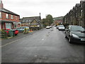
8
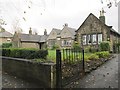
Cottage Homes - Riverdale Road
Part of the Sunnylee Estate - built 1915
Image: © Betty Longbottom
Taken: 6 Nov 2013
0.09 miles
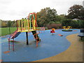
9
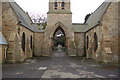
Otley cemetery
Disused Cemetery Chapels
Image: © John Sparshatt
Taken: 7 Apr 2008
0.09 miles