IMAGES TAKEN NEAR TO
Kings Close, OTLEY, LS21 1RQ
Introduction
This page details the photographs taken nearby to Kings Close, LS21 1RQ by members of the Geograph project.
The Geograph project started in 2005 with the aim of publishing, organising and preserving representative images for every square kilometre of Great Britain, Ireland and the Isle of Man.

There are currently over 7.5m images from over14,400 individuals and you can help contribute to the project by visiting https://www.geograph.org.uk
Image Map
Images are licensed for reuse under creativecommons.org/licenses/by-sa/2.0
Notes
- Clicking on the map will re-center to the selected point.
- The higher the marker number, the further away the image location is from the centre of the postcode.
Image Listing (45 Images Found)
Images are licensed for reuse under creativecommons.org/licenses/by-sa/2.0
Image
Details
Distance
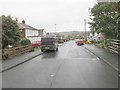
1
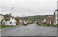
St Clair Road - looking towards Lisker Drive
Image: © Betty Longbottom
Taken: 6 Nov 2013
0.08 miles
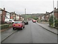
3
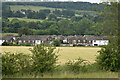
Distant view of houses at Cambridge, on the edge of Otley
Image: © David Martin
Taken: 24 Jun 2022
0.10 miles
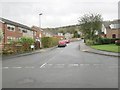
7
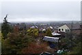
Housing in Otley
Looking across the roofs of houses from Leeds Road in Otley.
Image: © DS Pugh
Taken: 2 Apr 2018
0.15 miles
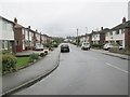
8
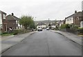
Cambridge Grove - looking towards Cambridge Way
Image: © Betty Longbottom
Taken: 6 Nov 2013
0.15 miles
10
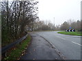
Roundabout on the A660, Cambridge, Otley
Looking east.
Image: © JThomas
Taken: 23 Nov 2018
0.17 miles