IMAGES TAKEN NEAR TO
Bank Top Lane, OTLEY, LS21 1PU
Introduction
This page details the photographs taken nearby to Bank Top Lane, LS21 1PU by members of the Geograph project.
The Geograph project started in 2005 with the aim of publishing, organising and preserving representative images for every square kilometre of Great Britain, Ireland and the Isle of Man.

There are currently over 7.5m images from over14,400 individuals and you can help contribute to the project by visiting https://www.geograph.org.uk
Image Map (Loading...)


Getting Data...Please wait
Leaflet Map data © OpenStreetMap
Images are licensed for reuse under creativecommons.org/licenses/by-sa/2.0
Notes
- Clicking on the map will re-center to the selected point.
- The higher the marker number, the further away the image location is from the centre of the postcode.
Image Listing (18 Images Found)
Images are licensed for reuse under creativecommons.org/licenses/by-sa/2.0
Image
Details
Distance
1

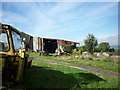
Bankside Farm
Viewed from the nearby bridleway. See also Image taken ten years earlier. Note Arthington Viaduct can be seen in the distance.
Image: © Stephen Craven
Taken: 19 May 2018
0.02 miles
2
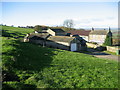
Bank Side Farm
Farming Complex passed on the Ebor Way between Harewood and Bramhope
Image: © Chris Heaton
Taken: 12 Nov 2008
0.03 miles
3

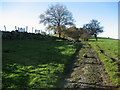
Lambs on Bank Top Lane
I dismounted from my bicycle when I came towards these lambs sitting on a bridleway, but they still ran away when I walked past them.
Image: © Stephen Craven
Taken: 19 May 2018
0.04 miles
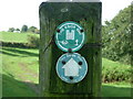
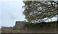
6
Ebor Way near Bank Side Farm
The Long Distance Footpath heading west from the farming complex.
Image: © Chris Heaton
Taken: 12 Nov 2008
0.04 miles
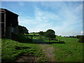
7
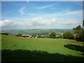
Bank Side Farm
Taken from halfway down from The Bowshaws.
Image: © Ian S
Taken: 2 Oct 2010
0.05 miles
8
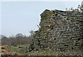
Eccup, Bank Top Lane
The benchmark is cut into the largest stone in the lower courses of the gable end of the ruined farm building.
Image: © Mel Towler
Taken: 22 Dec 2022
0.05 miles
9
Eccup, ruined farm building
There is a benchmark cut into the largest stone in the lower courses of the gable end of the ruined farm building.
Image: © Mel Towler
Taken: 22 Dec 2022
0.05 miles