IMAGES TAKEN NEAR TO
Harewood Road, OTLEY, LS21 1PR
Introduction
This page details the photographs taken nearby to Harewood Road, LS21 1PR by members of the Geograph project.
The Geograph project started in 2005 with the aim of publishing, organising and preserving representative images for every square kilometre of Great Britain, Ireland and the Isle of Man.

There are currently over 7.5m images from over14,400 individuals and you can help contribute to the project by visiting https://www.geograph.org.uk
Image Map (Loading...)


Getting Data...Please wait
Leaflet Map data © OpenStreetMap
Images are licensed for reuse under creativecommons.org/licenses/by-sa/2.0
Notes
- Clicking on the map will re-center to the selected point.
- The higher the marker number, the further away the image location is from the centre of the postcode.
Image Listing (7 Images Found)
Images are licensed for reuse under creativecommons.org/licenses/by-sa/2.0
Image
Details
Distance
1
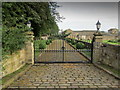
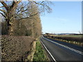
Entrance to The Nunnery
Now a private residence - the entrance and gates from Arthington Lane - the A659.
Image: © Chris Heaton
Taken: 21 Aug 2012
0.05 miles
3
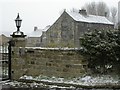
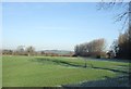
The Nunnery
Now a private residence, a Cluniac Nunnery was founded on this site in 1150 by Peter de Arthington.
Image: © Derek Parkinson
Taken: 12 Mar 2006
0.12 miles
6
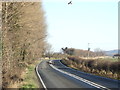
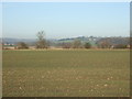
Red Kites over Arthington Lane
Rare Red Kites (Milvus milvus) attracted by road kill on Arthington Lane.
Image: © JThomas
Taken: 14 Jan 2012
0.15 miles