IMAGES TAKEN NEAR TO
Harewood Road, OTLEY, LS21 1PN
Introduction
This page details the photographs taken nearby to Harewood Road, LS21 1PN by members of the Geograph project.
The Geograph project started in 2005 with the aim of publishing, organising and preserving representative images for every square kilometre of Great Britain, Ireland and the Isle of Man.

There are currently over 7.5m images from over14,400 individuals and you can help contribute to the project by visiting https://www.geograph.org.uk
Image Map
Images are licensed for reuse under creativecommons.org/licenses/by-sa/2.0
Notes
- Clicking on the map will re-center to the selected point.
- The higher the marker number, the further away the image location is from the centre of the postcode.
Image Listing (27 Images Found)
Images are licensed for reuse under creativecommons.org/licenses/by-sa/2.0
Image
Details
Distance
1
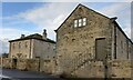
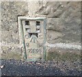
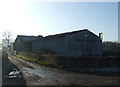
Arthington, Holt Farm Barn
The OS Flush Bracket 2336 is embedded into the gable end of Holt Farm Barn. This is a farm building now converted to private homes.
Image: © Mel Towler
Taken: 17 Dec 2022
0.02 miles
2
Arthington, Holt Farm Barn
The OS Flush Bracket 2336 is embedded into the gable end of Holt Farm Barn. This is a farm building now converted to private homes.
Image: © Mel Towler
Taken: 17 Dec 2022
0.02 miles
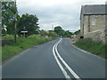
5
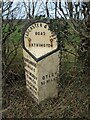
Old/new milestone
When the new casting was made for this milestone at a foundry in Halifax the date 2010 was cast at the base of the right-hand side. This can just be seen. This milestone also had the top edge and the edges of the bevel painted black.
Image: © Chris Minto
Taken: 19 Mar 2023
0.15 miles
6
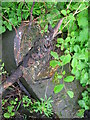
Old milestone
In 2006 some local people from Arthington were litter picking and found the milestone at the east end of the village in this state. The backing stone was broken and only the top metal section was found. In 2010 the Parish Cuncil sourced enough funds to have a replacement casting made. The remaining piece of stone was fastened to a new stone base with the, now complete, milestone set a little further back from the road edge.
Image: © Chris Minto
Taken: 7 May 2006
0.15 miles
8
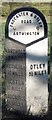
Replica Milestone by the A659, Arthington Lane, Arthington
Replica metal plate attached to stone post by the A659, in parish of ARTHINGTON (LEEDS District), Arthington Lane near Ingfield Farm, at gap in hedge opposite large tree, on North side of road. WR iron casting, erected by the County Council in the 21st century.
Inscription reads:-
: HAREWOOD / 3 MILES / WETHERBY / 9¼ MILES / BOSTON / 10 MILES / TADCASTER / 14 MILES : : TADCASTER & OTLEY / ROAD / ARTHINGTON : : OTLEY / 5¼ MILES / 2010 :
Milestone Society National ID: YW_TCOT14.
Image: © C Minto
Taken: 7 May 2006
0.16 miles
9
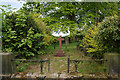
Grave of William Sheepshanks
The inscription below the cross reads "Sacred to the memory of William Sheepshanks founder of this church died 31st March 1872 aged 85".
Image: © Mark Anderson
Taken: 12 May 2010
0.16 miles