IMAGES TAKEN NEAR TO
Arthington Lane, OTLEY, LS21 1PH
Introduction
This page details the photographs taken nearby to Arthington Lane, LS21 1PH by members of the Geograph project.
The Geograph project started in 2005 with the aim of publishing, organising and preserving representative images for every square kilometre of Great Britain, Ireland and the Isle of Man.

There are currently over 7.5m images from over14,400 individuals and you can help contribute to the project by visiting https://www.geograph.org.uk
Image Map (Loading...)


Getting Data...Please wait
Leaflet Map data © OpenStreetMap
Images are licensed for reuse under creativecommons.org/licenses/by-sa/2.0
Notes
- Clicking on the map will re-center to the selected point.
- The higher the marker number, the further away the image location is from the centre of the postcode.
Image Listing (24 Images Found)
Images are licensed for reuse under creativecommons.org/licenses/by-sa/2.0
Image
Details
Distance
1
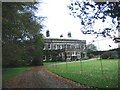
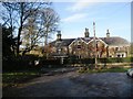
Arthington Hall, Arthington
The OS grid line splits Arthington Hall from east to west. The southern part of the Hall is at Image Image and the northern part is in Image This is the northern part of the Hall.
There is also a view of the western facade Image
Image: © Bill Henderson
Taken: 26 Oct 2006
0.04 miles
2
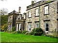
Arthington Hall, Arthington
This is the western facade of the Hall and is in two OS grid squares. The northern part of the facade is at Image Image and the southern part in Image Image
Image: © Bill Henderson
Taken: 26 Oct 2006
0.05 miles
3
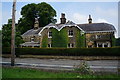
Arthington Hall, Arthington
The O/S grid line splits Arthington Hall from west to east. The southern part of the Hall at grid reference SE274449 and the northern part is at grid reference SE274450 Image This photograph is the southern facade of the Hall.
There is also a view of the western facade Image
Image: © Bill Henderson
Taken: 26 Oct 2006
0.05 miles
4
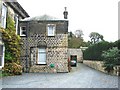
Arthington, house on north side A659
There is a very worn and weathered benchmark cut into a left cornerstone of the gable end of the property on the north side of the A659.
Image: © Mel Towler
Taken: 17 Dec 2022
0.18 miles
5
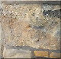
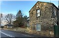
Arthington, house north side A659
The very worn and weathered benchmark is cut into a left cornerstone of the property on the north side of the A659.
Image: © Mel Towler
Taken: 17 Dec 2022
0.18 miles
6

Old Direction Sign - Signpost by the A659, Arthington Lane, Arthington
Annulus and bar finial - 3 arms; WR Yorks halo with NGR by the A659, in parish of Arthington (Leeds District), Arthington, junction with Black Hill Road.
To be surveyed
Milestone Society National ID: YW_SE2744
Image: © A Riley
Taken: 5 Oct 2008
0.18 miles
9
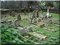
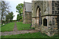
St Peter's Church, Arthington, Graveyard
Image: © Alexander P Kapp
Taken: 20 Feb 2008
0.23 miles
10
Cut Bench Mark, St Peter's Church
A cut bench mark is present on the north-western corner of the tower at the far right of the photograph. A closer view of the bench mark can be seen here: Image
Image: © Mark Anderson
Taken: 12 May 2010
0.24 miles