IMAGES TAKEN NEAR TO
Mill Croft Estate, OTLEY, LS21 1LT
Introduction
This page details the photographs taken nearby to Mill Croft Estate, LS21 1LT by members of the Geograph project.
The Geograph project started in 2005 with the aim of publishing, organising and preserving representative images for every square kilometre of Great Britain, Ireland and the Isle of Man.

There are currently over 7.5m images from over14,400 individuals and you can help contribute to the project by visiting https://www.geograph.org.uk
Image Map
Images are licensed for reuse under creativecommons.org/licenses/by-sa/2.0
Notes
- Clicking on the map will re-center to the selected point.
- The higher the marker number, the further away the image location is from the centre of the postcode.
Image Listing (198 Images Found)
Images are licensed for reuse under creativecommons.org/licenses/by-sa/2.0
Image
Details
Distance
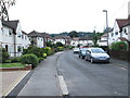
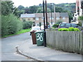
4

Wharfedale Court, Pool
Sheltered housing off the stretch of road shown in Image
Image: © Derek Harper
Taken: 29 Dec 2016
0.06 miles
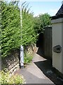
5

The White Hart, Main Street, Pool-in-Wharfedale
Image: © Alexander P Kapp
Taken: 20 Feb 2008
0.06 miles
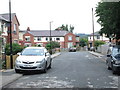
8
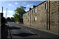
Main Street, Pool
There is a flush bracket bench mark on the wall on the right. A closer view can be seen here: Image
Image: © Mark Anderson
Taken: 20 Jun 2010
0.07 miles
9
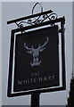
Sign for the White Hart, Pool in Wharfedale
Image: © JThomas
Taken: 23 Nov 2018
0.07 miles
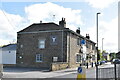
10
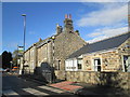
The White Hart public house Pool
On A659 entering village from Arthington
Image: © Martin Dawes
Taken: 29 Oct 2018
0.07 miles