IMAGES TAKEN NEAR TO
Oakdale Drive, OTLEY, LS21 1LJ
Introduction
This page details the photographs taken nearby to Oakdale Drive, LS21 1LJ by members of the Geograph project.
The Geograph project started in 2005 with the aim of publishing, organising and preserving representative images for every square kilometre of Great Britain, Ireland and the Isle of Man.

There are currently over 7.5m images from over14,400 individuals and you can help contribute to the project by visiting https://www.geograph.org.uk
Image Map
Images are licensed for reuse under creativecommons.org/licenses/by-sa/2.0
Notes
- Clicking on the map will re-center to the selected point.
- The higher the marker number, the further away the image location is from the centre of the postcode.
Image Listing (106 Images Found)
Images are licensed for reuse under creativecommons.org/licenses/by-sa/2.0
Image
Details
Distance
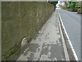
2
Pool in Wharfedale, milestone
According to the OS benchmark database there is a benchmark cut into the milestone on the north side of A659. The roadside wall has been built around the milestone obscuring any cutmark that was present.
Image: © Mel Towler
Taken: 17 Dec 2022
0.03 miles
3
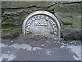
Old milestone
All that remains of the WRCC milestone at the east end of Pool near a lamppost and a 'Bends' sign.. On OS 50 000 maps milemarkers are noted as MP or MS even for the same style of milemarker. The mileages for this stone were Harewood 5/Wetherby 11¼/Boston 12/Tadcaster 16 on the left face and Otley 3¼ on the right.
Image: © Chris Minto
Taken: 19 Mar 2023
0.03 miles
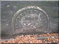
4
Old milestone
The wall into which this remaining piece of WRCC milestone is set looks quite old. So maybe this milestone was damaged a long time ago
Image: © Chris Minto
Taken: 19 Mar 2023
0.03 miles
5
Old Milestone by the A659, Arthington Lane, Pool-in-Wharfedale
Metal plate detached from post by the A659, in parish of Pool (Leeds District), Arthington Lane, East end of Pool, at base of wall, near lamppost 16A294 and 'Bends' sign S4A294, opposite White Croft, on North side of road. WR iron casting, erected by the County Council in the 19th century.
Inscription once read:-
: (HAREWOOD / 5 MILES / WETHERBY / 11¼ MILES / BOSTON / 12 MILES / TADCASTER / 16 MILES) : : TADCASTER & OTLEY / ROAD / POOL : : (OTLEY / 3¼ MILES) :
Milestone Society National ID: YW_TCOT16.
Image: © C Minto
Taken: 6 May 2011
0.04 miles
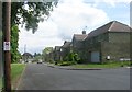
7
Park Court - looking towards Park Way
Image: © Betty Longbottom
Taken: 23 Aug 2013
0.05 miles
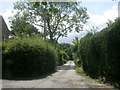
8
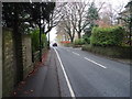
Arthington Lane (A659), Pool in Wharfedale
Looking south east.
Image: © JThomas
Taken: 23 Nov 2018
0.06 miles
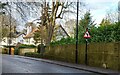
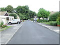
9
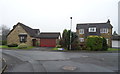
Houses on Stonedale Close, Pool in Wharfedale
Image: © JThomas
Taken: 23 Nov 2018
0.09 miles