IMAGES TAKEN NEAR TO
Far Row, OTLEY, LS21 1ES
Introduction
This page details the photographs taken nearby to Far Row, LS21 1ES by members of the Geograph project.
The Geograph project started in 2005 with the aim of publishing, organising and preserving representative images for every square kilometre of Great Britain, Ireland and the Isle of Man.

There are currently over 7.5m images from over14,400 individuals and you can help contribute to the project by visiting https://www.geograph.org.uk
Image Map
Images are licensed for reuse under creativecommons.org/licenses/by-sa/2.0
Notes
- Clicking on the map will re-center to the selected point.
- The higher the marker number, the further away the image location is from the centre of the postcode.
Image Listing (57 Images Found)
Images are licensed for reuse under creativecommons.org/licenses/by-sa/2.0
Image
Details
Distance
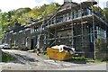
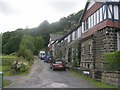
1
Far Row
Deep in the woods is this isolated row of houses, presumably built for the managers of the adjacent quarries. According to the history of the quarries at https://www.poolinwharfedalehistory.co.uk/6-pool-bank-quarries/ they were built in 1876.
Image: © Stephen Craven
Taken: 28 Dec 2020
0.00 miles
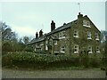
2
Far Row, Pool Bank
This row of Victorian terraced cottages stand in the middle of a wooded area on Pool Bank, approached by a track or footpaths. The cottages were built for quarry workers, the area being extensively quarried for high quality sandstone.
Image: © Gordon Hatton
Taken: 27 Jan 2009
0.01 miles
3
Course of old tramway
The inclined tramway that took stone from Pool Bank quarries to the Leeds-Otley railway at Pool station ran in this cutting, as far as I can make out from comparing old and present day maps. A full history of the quarries, including the cable-operated tramway, can be found at https://www.poolinwharfedalehistory.co.uk/6-pool-bank-quarries/
Image: © Stephen Craven
Taken: 28 Dec 2020
0.03 miles
4
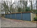
Garages at Far Row
See Image for the houses to which these relate.
Image: © Stephen Craven
Taken: 28 Dec 2020
0.03 miles
5
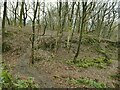
Path through Pool Bank quarries
The path drops and climbs its way across the remnants of a once extensive quarry, now woodland. A full history of the quarries can be found at https://www.poolinwharfedalehistory.co.uk/6-pool-bank-quarries/
Image: © Stephen Craven
Taken: 28 Dec 2020
0.05 miles
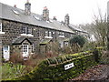
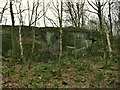
6
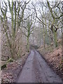
Track to Far Row
This motorable track links the cottages at Far Row to the A660, passing through an area that was quarried for sandstone in the 19th century.
Image: © Gordon Hatton
Taken: 27 Jan 2009
0.05 miles
7
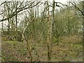
Overgrown old quarry at Pool Bank
This is at the top of the extensively quarried (and now wooded) hillside above Pool. A full history of the quarries can be found at https://www.poolinwharfedalehistory.co.uk/6-pool-bank-quarries/
Image: © Stephen Craven
Taken: 28 Dec 2020
0.07 miles
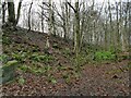
9
The top of Pool Bank quarries
The once extensive quarry, now woodland, covers part of the slope above Pool village but stopped where it reached farmland at the top of the slope. A full history of the quarries can be found at https://www.poolinwharfedalehistory.co.uk/6-pool-bank-quarries/
Image: © Stephen Craven
Taken: 28 Dec 2020
0.08 miles