IMAGES TAKEN NEAR TO
Manor Street, OTLEY, LS21 1AX
Introduction
This page details the photographs taken nearby to Manor Street, LS21 1AX by members of the Geograph project.
The Geograph project started in 2005 with the aim of publishing, organising and preserving representative images for every square kilometre of Great Britain, Ireland and the Isle of Man.

There are currently over 7.5m images from over14,400 individuals and you can help contribute to the project by visiting https://www.geograph.org.uk
Image Map (Loading...)


Getting Data...Please wait
Leaflet Map data © OpenStreetMap
Images are licensed for reuse under creativecommons.org/licenses/by-sa/2.0
Notes
- Clicking on the map will re-center to the selected point.
- The higher the marker number, the further away the image location is from the centre of the postcode.
Image Listing (522 Images Found)
Images are licensed for reuse under creativecommons.org/licenses/by-sa/2.0
Image
Details
Distance
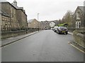
1
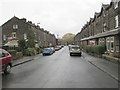
Manor Street - viewed from Riverdale Road
Image: © Betty Longbottom
Taken: 6 Nov 2013
0.01 miles
2
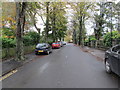
Riverdale Road - viewed from Manor Street
Image: © Betty Longbottom
Taken: 6 Nov 2013
0.03 miles
3
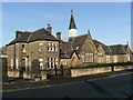
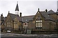
Converted school
This was once All Saints School.
Image: © SMJ
Taken: 24 Nov 2008
0.03 miles
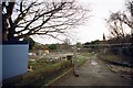
4
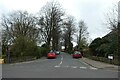
Riverdale Road
Looking along Riverdale Road from North Street.
Image: © DS Pugh
Taken: 2 Apr 2021
0.04 miles
5
Former School - Cattle Market Street
This has now been converted into flats.
Image: © Betty Longbottom
Taken: 16 Jun 2007
0.04 miles
6
Development site, Otley
I think this was once a part of the school, the buildings of which are visible in the centre background, although they've been converted into flats. As far as I can tell, this whole area (including Image) is to be developed as a care home for those with dementia and Alzheimer's. See http://www.brookesmithplanning.com/2011/07/have-your-say-consultation-exercise/ for more information.
Image: © John Winder
Taken: 30 Dec 2014
0.04 miles
7
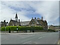
All Saints Court, Cattle Market Street, Otley
Originally a Board school of 1879, later a Middle School and now converted to housing. Listed grade II (list entry 1135230).
Image: © Stephen Craven
Taken: 21 May 2022
0.04 miles
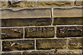
8
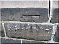
Ordnance Survey Cut Mark
The mark can be found on the former C of E school building. Now converted to dwellings and therefore in a private garden.
For more details see : http://www.bench-marks.org.uk/bm38393
Image: © Peter Wood
Taken: 13 Feb 2012
0.05 miles
9
North Parade - viewed from Cattle Market Street
Image: © Betty Longbottom
Taken: 6 Nov 2013
0.05 miles
10
Cut Bench Mark, Former School
Bench Mark Database: http://www.bench-marks.org.uk/bm38393
Image: © Mark Anderson
Taken: 25 Jun 2011
0.05 miles