IMAGES TAKEN NEAR TO
Ings Avenue, LEEDS, LS20 9HW
Introduction
This page details the photographs taken nearby to Ings Avenue, LS20 9HW by members of the Geograph project.
The Geograph project started in 2005 with the aim of publishing, organising and preserving representative images for every square kilometre of Great Britain, Ireland and the Isle of Man.

There are currently over 7.5m images from over14,400 individuals and you can help contribute to the project by visiting https://www.geograph.org.uk
Image Map (Loading...)


Getting Data...Please wait
Leaflet Map data © OpenStreetMap
Images are licensed for reuse under creativecommons.org/licenses/by-sa/2.0
Notes
- Clicking on the map will re-center to the selected point.
- The higher the marker number, the further away the image location is from the centre of the postcode.
Image Listing (73 Images Found)
Images are licensed for reuse under creativecommons.org/licenses/by-sa/2.0
Image
Details
Distance
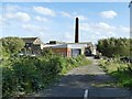
1
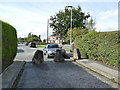
Ings Avenue, Guiseley
The rocks close it to through motor traffic.
Image: © Stephen Craven
Taken: 12 Sep 2020
0.01 miles

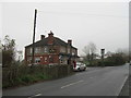
5
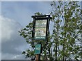
Sign for the Ings Inn, Ings Lane, Guiseley
See Image for the pub.
Image: © Stephen Craven
Taken: 12 Sep 2020
0.04 miles
6
Site for new housing off Ings Lane, Guiseley
A developer's sign promised 8 luxury houses coming soon.
Image: © Stephen Craven
Taken: 12 Sep 2020
0.04 miles
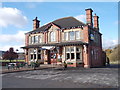
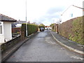
9
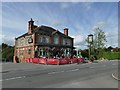
The Ings Inn, Ings Lane, Guiseley
It looks Victorian but was in fact built in 1933 to replace an earlier building on the same site. See also Image
Image: © Stephen Craven
Taken: 12 Sep 2020
0.05 miles
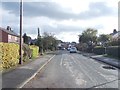
10
Nethercliffe Road - Netherfield Road
Image: © Betty Longbottom
Taken: 2 Nov 2012
0.06 miles